
Technical Notes 2026, Issue 50 - EDC 3 years Carriageway and Footway Resurfacing Programme
Details
- The report is intended to provide an update to Elected Members on the provisional Roads Carriageway & Footway Resurfacing Programme for 2026/2027, 2027/2028 and 2028/2029.
- The list will be finalised, and an Annual Programme confirmed for 2026/27 in later in April 2026 based on the capital budget allocated for the financial year.
- The remaining locations will be monitored in the interim period with an annual programme confirmed for 2027/2028 and 2028/2029 at the start of each respective financial year once capital budgets have been confirmed for the year.
- It is necessary that whatever funds are available are spent on the correct schemes at the right time and that schemes are prioritised using optimisation methodologies to maximise risk reduction and minimise whole life costs.
- The methods that East Dunbartonshire Council use to optimise our programme have been developed from best practice methods found in “Well-Managed Highway Infrastructure – A Code of Practice”.
- The "Well-managed Highway Infrastructure - A Code of Practice" provides guidelines for local highway authorities in the UK to adopt a risk-based approach to managing highway networks effectively and informs the East Dunbartonshire Council Road Inspection and Maintenance Plan 2024 to 2027.
- The carriageway and footway element of the capital programme is based on a scheme of prioritisation which uses condition assessment scores, prioritisation criteria and weightings to determine which projects should be prioritised for investment.
- The condition of East Dunbartonshire Council roads is assessed annually as part of the Scottish Roads Maintenance Condition Survey (SRMCS), an independent survey of road conditions in all 32 Scottish local authorities. The survey provides each local authority with a Road Condition Index (RCI) which identifies the percentage of roads in need of maintenance.
- The figures below represent the carriageway condition survey conducted by East Dunbartonshire Council, utilising the Red-Amber-Green rating system. This survey is produced by WDM on behalf of Scottish local councils, providing an objective assessment of road surface conditions to guide maintenance priorities and infrastructure planning. For context, a comparison between the reports for 2023–2025 and 2024–2026 is included to highlight any changes or trends in road conditions over time.
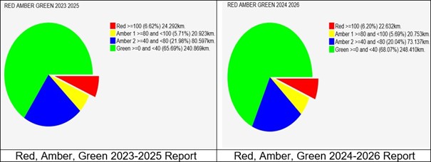
Click to enlarge.
- The current East Dunbartonshire Council Road Condition Index is 33% which is down from the previous RCI of 35.1%. This is a encouraging step and the Service will look to continue this positive direction.
- A visual inspection by road officers is source of accuracy on the condition of the network, in greater detail.
- In addition, the Service will utilise Gaist Surveys (Unrivalled roadscape intelligence - Gaist). This full network survey allows the Roads Network Operations team a snapshot of reliable carriageway condition data that will empower the team and officers to make the best investment decisions based on accurate data.
- The Team also investigates carriageway and footway maintenance issues to target improvements. The team analyse condition data available for each asset to identify need for maintenance and/or improvement.
- Network Hierarchy – the team ensure that greater priority is given to roads and key assets on roads that have the greatest usage or need.
- Risk – the team will give a higher priority to schemes that pose a risk to public safety.
- Value for Money – the team will use the right treatments at the right time in order to produce cost effective solutions.
- The Roads Network Operations Management – the team endeavour to ensure works are programmed to minimise disruption to users and maximise benefits to the community by combining schemes for different assets together where possible. For example, programme traffic sensitive roads during school holidays, if possible, etc.
- Each asset has its own set of prioritisation criteria and weighting sets based on the principles above which consider the unique attributes and requirements of each asset.
- It is the aim of the Roads Network Operations teams to deliver all of the schemes listed in this report over a three-year period. However, this may not be possible due to unforeseen or emergency works causing potential conflict on the network. This is why there needs to be an element of flexibility in the programme to allow officers to react to any changes that may arise.
- If a location is not delivered due to a conflict it will remain on the overall programme and will be re-prioritised for delivery in a future financial year or will be on hold until deploy a suitable contractor i.e., locations contaminate with coal tar.
- The capital work programme will be reviewed regularly to ensure that any adjustment is made to the programme as soon as possible with these reflecting in the annual/quarterly updates issued to elected members in April, July, October, and January each year.
- The provisional programme of 2026/27 is laid out for your information. The programme is based on the capital allocation for the current year which was used as a guide to allow for preparations to be made prior to any budget decisions being taken by Council.
- Footway and Carriageways are a maturing asset and in constant use o the condition will change over time and it is important that there is recognition that the resurfacing programmes are provisionally only at this time. These will be subject to change depending on the outcome of the annual or ad-hoc/reactive condition assessment review process, result of coal tar, conflict with utility works, weather permit, and any other unforeseen circumstances.
- The investment in the East Dunbartonshire Council carriageways and footways improves the accessibility and safety of the road and footway network and therefore has a positive impact for all users, particularly older people, and those with a disability.
2026/27 Carriageway Programme (with no programmed dates)
| Location | Town | Comments |
|---|---|---|
|
Ballater Drive |
Bearsden |
Between Braemar and Coronation Way |
|
Stockiemuir Road (phase 5) |
Bearsden |
From Craighead drive toward Craigton Roundabout |
|
Campsie Road (Near traffic lights and Urban sections) |
Lennoxtown |
Junction goes to golf club -200 m toward Torrance |
|
Kilsyth Road (phase 3) |
Kirkintilloch |
Cala Home to council depot (postponed due to clash with SGN works) |
|
Kirkintilloch Road (phase3) |
Bishopbriggs |
Between Cadder Roundabout & Westerhill Road |
|
Milton Road |
Kirkintilloch |
From Glasgow Road to Bridge |
|
Craigmaddie Road |
Balmore |
A81 to 400m before Tower Road |
|
Chryston Road |
Kirkintilloch |
Rail bridge to Ruther Ave-overlay |
|
Lenzie Road |
Kirkintilloch |
Laurel Ave to Myrtle Ave |
|
Strathblane Road (Phase 2) |
Milngavie |
100m north of Marchfield to Scottish Water access |
|
Milngavie Road (phase 4) |
Bearsden |
Manse Road to Mosshead |
|
Milngavie Road (phase 5) |
Bearsden |
Manse Road to Mosshead |
|
Bellfield Road & Washington Road |
Kirkintilloch |
School to Glasgow Road |
|
Lindsaybeg Road (phase 1) |
Lenzie |
Auchinloch to Easter Gaingaber Roundabout -Anti Skids |
|
Lindsaybeg Road (phase 2) |
Lenzie |
Easter Gaingaber to roundabout |
|
Waterside Road |
Kirkintilloch |
Market to Merkland |
|
Waterside Road |
Kirkintilloch |
Outside Gartconner Primary School |
|
Park Road |
Bishopbriggs |
Hillside Dr to no. 143 (outside School) |
|
Watermill Ave (phase 1) |
Lenzie |
Full |
|
Watermill Ave (phase 2) & Farm Park plus Millas Plc |
Lenzie |
Full |
|
Woodiliee Road |
Kirkintilloch |
Full |
|
Initiative road |
Kirkintilloch |
All the legs to and from Lindsaybeg Roundabout |
|
New Lairdsland Road |
Kirkintilloch |
From Canal to Catherine St |
|
Burnbrae Road (phase 2) |
Kirkintilloch |
Bridge deck to Muckcroft Road |
|
Benvue Road |
Lennextown |
Full |
|
Orchard Field |
Lenzie |
Full |
|
Waverley Crescent |
Kirkintilloch |
Full |
|
Tower Road/Back O' Hill Road |
Torrance |
Full Length Back O Hill Road |
|
Redmoss Road |
MOC |
TBC |
|
Glenwood Road |
Lenzie |
Full |
|
Ballaig Avenue |
Bearsden |
Full |
|
Marmion Drive |
Kirkintilloch |
Full |
|
Hilton Road |
Milngavie |
Full |
|
Burnside Avenue |
Kirkintilloch |
Full |
|
John Street |
Kirkintilloch |
Full |
|
St Columba Drive |
Kirkintilloch |
Full |
|
Millburn Street |
Lennextown |
Full |
|
Moncrieff Avenue |
Lenzie |
Full |
|
Lock Road |
Kirkintilloch |
Woodilee to Kirksyde Avenue |
|
Willow Avenue and Cedar |
Lenzie |
Full |
|
Kirk St |
Milngavie |
Full |
|
Badenoch Road, Loran Place, Badenoch Road |
Kirkintilloch |
Full |
|
Finlay Rise, including Auchencruive |
Milngavie |
Auchenhowie Road to Auchencruive |
2026/27 Footway Programme (with no programmed dates)
| Location | Town | Comments |
|---|---|---|
|
Milngavie Road (phase 3) |
Bearsden |
One side Kessington Hall side Opposite Asda |
|
Kirkintilloch Road |
Bishopbriggs |
Meadow Burn to opposite Westerhill Road - one side |
|
Inveroran Drive (phase 2) |
Bearsden |
Glendaruel Ave to Durness Ave - both sides |
|
Gallowhill Road (Phase 1) |
Lenzie |
Beech to Moss |
|
Elm Ave |
Lenzie |
Beech Road to Number 6 |
|
Roman Road |
Bearsden |
From School to Grange Road/Rail Bridge |
|
South Main Road |
Milngavie |
Full Length - both sides |
|
Gallowhill Road (Phase 2) |
Kirkintilloch |
Kirkintilloch Road to Beech - both sides |
|
Park Crescent |
Torrance |
Full Length |
|
Thorn Road |
Bearsden |
Thorn Drive to Golf club |
|
Main st |
Torrance |
Kelvin Bridge RB to Campsie Rd |
2027/28 Carriageway Programme (with no programmed dates)
| Location | Town | Comments |
|---|---|---|
|
Southmain Road |
Milngavie |
Full length |
|
Glenorchard |
Balmore |
Golf Club Rd to Woodend house |
|
Baldernock Linn |
Balmore |
Overlay |
|
Acre Valley Road |
Torrance |
Overlay |
|
Campsie Drive (phase 2) |
Milngavie |
Phase 2 (between No 51 and junction of Bleurs St)- Phase 1 done 2024 |
|
Allander Road Phase 2 |
Milngavie |
Numbers 42 - 74 |
|
West Balgrochan Road |
Torrance |
Maitland Drive to Acre Valley Road |
|
Westercledden Road |
Bishopbriggs |
Laggan Rd to Woodhill Rd |
|
Angus Ave |
Bishopbriggs |
Torr Rd to Westercledden Rd |
|
Stockiemuir Road (phase 6) |
Bearsden |
TBC |
|
Thorn Road |
Bearsden |
Between Bearsden cross and Thorn Drive |
|
Waterside Road from Oxgang roundabout to Merkland |
Kirkintilloch |
From Oxgang roundabout to Merkland - 600sqm Anti-skid required |
|
Park Road |
Bishopbriggs |
Kirkintilloch Rd to Hillside |
|
Park Road |
Bishopbriggs |
Hillside to End of Cul de sac |
|
Kirkintilloch Road |
Lenzie |
Beech Road to cross |
|
Clober Road |
Milngavie |
Between B8050 and N. Claremont Ln. Junction included |
|
B8050 Craigdhu Road |
Milngavie |
From Clober Road to Ferguson Avenue |
|
Lee Crescent |
Bishopbriggs |
From Emerson Road to Crowhill Road |
|
Woodfield Avenue |
Bishopbriggs |
From Callieburn Road to Rose Dale |
|
Wellington Road |
Bishopbriggs |
At Low Moss industrial estate |
|
A81 Glasgow Road (phase 1) |
Milngavie |
From Station Road to Auchenhowie Road |
|
Gary Avenue |
Bearsden |
Full - Possible coal tar- Overlay |
|
Stockiemuir Ave |
Bearsden |
School to Mosshead Park |
|
Menteith Avenue |
Bishopbriggs |
From Hazel Dene to the pedestrian crossing at Etive Park/shiel |
|
Springfield rd Bishopbriggs |
Bishopbriggs |
From Callieburn to Hazel |
|
Ballaig Avenue |
Bearsden |
Full |
|
Buccleuch Drive + Brandon Drive |
Bearsden |
Full |
|
Queensberry Avenue |
Bearsden |
Full |
|
Kirkton Crescent |
MOC |
Full |
|
Meikle Bin Brae |
Lennoxtown |
Full |
|
Redhill View, Argyl Gardens, Bluebell Way, Warrer Wall |
Lennoxtown |
Full |
|
Eastermains & Drumhill |
Kirkintilloch |
Full |
|
Blacklands Place |
Lenzie |
Bridge To Lindsaybegg Rd |
|
Craigie Road, Foxes Grove, Meadowburn Ave |
Lenzie |
Full |
|
Cleish Avenue |
Bearsden |
Full |
|
Limetree Walk, Walnut, Cherry Place, Briar Bank, Larch Grove |
Kirkintilloch |
Full |
|
Craigmarloch Ave |
Torrance |
Full - postponed in 2024 so needed for re-programme |
|
Cromarty Ave |
Bishopbriggs |
Full - include junction with Solway Rd |
|
Northbank road |
Kirkintilloch |
TBC |
|
Millersneuk |
Lenzie |
TBC |
|
Westergreens Ave - part 1 |
Lenzie |
TBC |
|
Westergreens Ave - part 2 |
Lenzie |
TBC |
|
Kelvin view |
Twechar |
Full |
|
Gartshore Cres |
Twechar |
Kelvin view to Johnstone terrace |
2027/28 Footway Programme (with no programmed dates)
| Location | Town | Comments |
|---|---|---|
|
Springfield Road |
Bishopbriggs |
From Callieburn Road to Muir Street |
|
Garngaber Ave |
Lenzie |
TBC |
|
Garngaber Ave |
Milngavie |
TBC |
|
South Mains Road |
Milngavie |
TBC |
|
Kessington Road |
Bearsden |
Rannoch To Inveroran |
|
Roman Drive (Both Footways) from Roman Rd to Milngavie Rd |
Bearsden |
From Roman Rd to Milngavie Rd |
|
Menteith Avenue |
Bishopbriggs |
Woodhill Road to Hazel Dene, (both sides) |
|
Glasgow Road |
Milngavie |
From Railway Bridge to Waitrose |
|
Station Road |
Milngavie |
LH Footway from Glasgow Rd to Fulton Rd |
|
Strathblane Road |
Milngavie |
From Baldernock Rd to Opposite Moor Rd |
|
Killermonth Road |
Bearsden |
Speirs to Kessington - Missed from 2023 |
|
Prestonfield |
Milngavie |
Internal path + two cul de sac |
|
Gleenwood Garden |
Lenzie |
TBC |
|
Allander Road |
Milngavie |
TBC |
|
Douglas Muir Road |
Milngavie |
From Drumbeg Terrace to Castle Mains Road |
|
West Chapelton Ave |
Bearsden |
One side only |
2028/29 Carriageway Programme (with no programmed dates)
| Location | Town | Comments |
|---|---|---|
|
Kerr St |
Kirkintilloch |
Bank to Oxford St |
|
Birch View |
Bearsden |
Milngavie Rd to Train Station |
|
Kilsyth Road - Phase 4 |
Kirkintilloch |
Council depot to 200 meter after B023 |
|
Stockiemuir Road (phase 5) |
Milngavie |
TBC |
|
High St |
Kirkintilloch |
A806 Kirkintilloch Bypass to Hillhead RB |
|
Peel Glen Road |
Bearsden |
Duntocher to GCC boundary |
|
Balmore Road |
Milngavie |
100 metres from Allander RB toward new houses |
|
Kirkintilloch Road |
Bishopbriggs |
From Park Road to South Crosshill Rd |
|
Craighead Rd |
MOC |
Between Campsie Road and private road |
|
Woodburn Avenue |
Milngavie |
Between Kwik fit (Full junction including) to ped crossing at Station and junction with Park Road |
|
Roman Road |
Bearsden |
From School to Roman Drive |
|
Bankhead Rd |
Kirkintilloch |
Luggie Rd to 20mts past Back to Dykes Rd |
|
Duntocher Road |
Bearsden |
Ledi Drive junction to 100 meter after Antonine Rd |
|
Glasgow Road |
Milngavie |
From Station Rd to Auchenhowie Rd |
|
Balmuildy Road |
Bishopbriggs |
Stirling Drive to Hilton Depo and Buchley Eco Centre to Mavis Valley |
|
Falloch Road |
Milngavie |
Between Hunter Road and Achray Place |
|
Gartconnell Drive |
Bearsden |
Full - Drymen Rod to Gartconell Rd |
|
Conon Ave |
Bearsden |
Full |
|
The Loan |
Milngavie |
Full overlay |
|
Eastside |
Kirkintilloch |
Hillhead Roundabout (RB to be included) to Kilsyth Rd |
|
Cleish Avenue |
Bearsden |
Full |
|
Cairnview |
Kirkintilloch |
Bach O dykes to Bankhead |
|
Westergreens Ave |
Lenzie |
From JCT of Gallowhill Rd to NO 27 |
|
Cypress court |
Lenzie |
Full |
|
Ettrick Drive |
Bearsden |
Full |
|
Lawer Garden |
Bearsden |
Full |
|
Dunn Park |
Kirkintilloch |
Full |
|
Regent Square |
Lenzie |
Full |
|
Kelvin View |
Twechar |
Full |
|
Greenhill |
Bishopbriggs |
Full |
|
Oxgang Roundabout |
Kirkintilloch |
Oxgang Roundabout and all legs |
|
Kersland Drive |
Milngavie |
Full |
|
South Glassford Street |
Milngavie |
Full |
|
Muirlees Crescent |
Milngavie |
Full |
|
Benvue Road |
Lennextown |
Junction with Rowantree Place to Westerton |
|
Lindsaybeg Road |
Lenzie |
Junction with Burnbrae Road - include Anti Skids |
2028/29 Footway Programme (with no programmed dates)
| Location | Town | Comments |
|---|---|---|
|
Milngavie Road |
Milngavie |
Glasgow Rd to Kwik fit |
|
Kessington Road |
Bearsden |
Rannoch To Inveroran |
|
Boaghead Rd |
Kirkintilloch |
TBC |
|
Grampian Way (phase 2) |
Bearsden |
TBC |
|
Calder Gate & Hilton Park |
Bishopbriggs |
TBC |
|
Park Ave |
Milngavie |
Main section only - one side |
|
Maxwell Ave |
Bearsden |
TBC |
|
Allander Garden |
Bishopbriggs |
TBC |
|
Kelvin Road |
Milngavie |
TBC |
|
Craigdhu Rd |
Milngavie |
From Hunter RB to Clober Road - both sides |