On this page you will find information on:
- Introduction.
- National, Regional and Local Policy Context
- What is the East Dunbartonshire Green Network?.
- Delivery of networks of green infrastructure in development
- Good practice examples of green infrastructure.
- Further Information.
- Annexes.
This Supplementary Guidance is intended to support implementation of the East Dunbartonshire Local Development Plan (LDP2). The relationship between the LDP, Supplementary Guidance and Planning Guidance is established in Scottish Government Circular 6/2013, and summarised in the table below.
|
Document
|
Purpose and Scope |
|---|---|
|
LDP
|
Sets out the Council’s policies for the development and use of land, including community strategies which identify opportunities for development, for the period up to 10 years from adoption. |
|
Supplementary Guidance (SG):
|
SG is statutory as it forms part of the development plan and has that status for decision making. It is limited to the provision of further information or detail in respect of policies or proposals set out in the LDP. SG will be adopted with the LDP and lasts for the period of the plan. |
|
Planning Guidance
|
Non-statutory planning guidance may be used to provide detail on a range of subject areas. This form of guidance should not be termed SG and will not form part of the development plan. However, adoption of this guidance by the Council gives it formal status, meaning that it may be a material consideration in decision making. Planning guidance can be updated as required and without the need for scrutiny by Scottish Ministers. Such updates are normally required where a specific issue arises during the period of the plan. |
The objective of creating a high-quality and multi-functional green network based on well-planned, managed and interconnected green infrastructure, runs through national, strategic and local planning policy, and is fundamental to delivery of the placemaking agenda. Individual decisions on development proposals in a planning application should therefore: protect, enhance, and extend a network of green infrastructure.
2.1 National Policy
National Planning Framework 4 (NPF4) forms part of the statutory development plan for East Dunbartonshire, and it should be read alongside this supplementary guidance. NPF4 includes policies on green and blue infrastructure (Policy 20) and play, recreation and sport (Policy 21). NPF4 identifies the Central Scotland Green Network (CSGN) as a national development which will play a key role in tackling the challenges of climate change and biodiversity loss including by building and strengthening nature networks. It confirms that a greener approach to development will improve placemaking, can contribute to the roll-out of 20 minute neighbourhoods and will benefit biodiversity connectivity. The CSGN Vision is that:
‘By 2050, Central Scotland has been transformed into a place where the environment adds value to the economy and where people’s lives are enriched by its quality.'
The CSGN takes a holistic approach to solving the biggest issues facing the environmental wellbeing of central Scotland. A huge number of partners are involved in delivering projects that are grouped into four interconnected work streams:
-
Developing Natural Climate Solutions
-
Making Liveable Places
-
Promoting Health and Wellbeing
-
Supporting a Green Recovery.
East Dunbartonshire Council has signed up to the CSGN’s Local Authority Concordat, which recognises its commitment to formally help deliver the CSGN vision and highlights the fundamental role local authorities have to play in helping to achieve the network’s aims, as well as the opportunities the CSGN has to offer.
Scotland’s Climate Change Plan, Scottish Government 2020, is the strategic delivery plan for meeting our emissions reduction targets and updated the 2018 Climate Change Plan [opens in a new window] in response to the global climate emergency. The new and ambitious emissions reduction targets set out in the Climate Change (Scotland) Act 2009 [opens in a new window] were amended by the Climate Change (Emissions Reduction Targets) (Scotland) Act 2019 [opens in a new window]. This 2019 Act increases the ambition of Scotland’s emissions reduction targets to net zero by 2045. The plan update [opens in a new window] sets out a pathway to meeting Scotland’s emissions reduction targets over the period to 2032.
In light of the unprecedented circumstances we are facing as a result of the COVID-19 pandemic, this plan update is also a key strategic document for Scotland’s green economic recovery. A green recovery will set us on a pathway towards our emissions reduction targets in a way that prioritises economic, social and environmental wellbeing. The Climate Change Plan update includes a number of transformational commitments and actions to deliver on both our emissions reduction targets and ensure a green recovery. These include woodland planting and peatland restoration, which are both habitats that can be part of the green network, and reducing car travel - supported by the access links of the green network.
Scottish Biodiversity Strategy Post-2020: Statement of Intent, Scottish Government 2020. This sets the direction for a new biodiversity strategy which will respond to the increased urgency for action to tackle the twin challenges of biodiversity loss and climate change. Green infrastructure and the green network can be biodiverse to help habitats and species flourish and adapt to climate change.
Scotland’s Forestry Strategy 2019 to 2029 and the UK Forestry Standard 2017 are national policy for forestry and woodland management in Scotland. The strategy presents a 50-year vision and 10-year framework of actions to expand, protect and enhance Scotland’s forests and woodlands. Scotland's Forestry Strategy Implementation Plan 2020 to 2022 is used to monitor delivery of the strategy and will be kept under review. The standard is endorsed by the Scottish Government and defines standards and requirements, is a basis for regulation and monitoring, and sets guidelines for sustainable forest management. It also recognises that forests have environmental, economic and social objectives.
2.2 Green Infrastructure Design and Placemaking Guidance
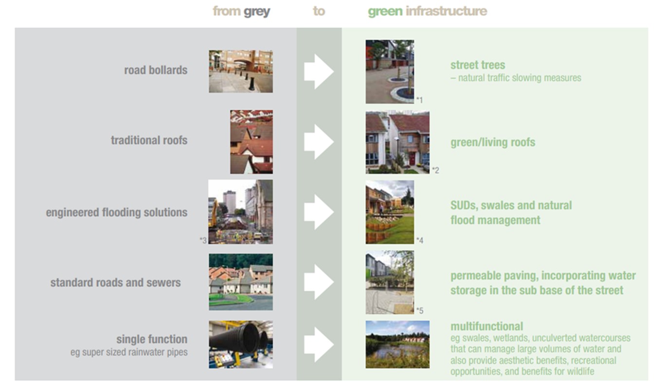
This Scottish Government 2011 guidance provides further information on the functions of green infrastructure and how to consider it during site appraisal and masterplanning. It identifies that green infrastructure can be provided at a range of scales of development and that there are different types of green infrastructure which will be increasingly used instead of hard infrastructure, as shown in Table 1 and Figure 2. It also provides examples of green infrastructure and how this contributes to placemaking.
| Table 1: Types of green infrastructure that can be used at different scales of development |
|---|
|
Building scale |
|
Green roof |
|
Hedges/living walls |
|
Gardens or grounds |
|
Sustainable Drainage Systems, including rainwater harvesting systems, permeable driveways, rain gardens and planter boxes |
|
Street/connections scale |
|
Paths/cycle routes |
|
Habitat links, including watercourses |
|
Street trees and other planting |
|
Sustainable Drainage Systems, including verges, swales, rain gardens and porous paving (incorporating water storage under the street) |
|
Neighbourhood scale |
|
Multi-functional open space |
|
Play space |
|
Community growing space |
|
Cemeteries |
|
Sustainable Drainage Systems pond |
|
Landscape framework and structural landscaping |
|
Area for natural flood-risk alleviation |
|
Strategic or local green network habitat and/or access links |
|
Locally important designed landscapes |
Figure 2: From grey to green infrastructure (Source: Scottish Government’s Green Infrastructure Design and Placemaking.)
2.3 Glasgow City Region Policy
GCV green network
The Council is a member of the Glasgow & Clyde Valley Green Network partnership, along with NatureScot, the Scottish Environment Protection Agency, the Glasgow Centre for Population Health, Scottish Forestry, Public Health Scotland, Clydeplan and the other seven local authorities in the Clyde Valley area. The idea of a green network was conceived in the Glasgow City Region when it was recognised that improving the environmental quality of the region would support the region’s economic competiveness, and the health and wellbeing of the region’s people. The green network would link urban and rural areas, and be transformational in terms of its vision, scale and commitment to action.
The partnership published a Green Network Blueprint, Glasgow & Clyde Valley Green Network 2019, which sets the strategic context for this guidance. This is a guide to where the strategic green network in Glasgow City Region should be protected and managed, and where there are gaps that need to be addressed, development should play a key role in addressing these gaps.
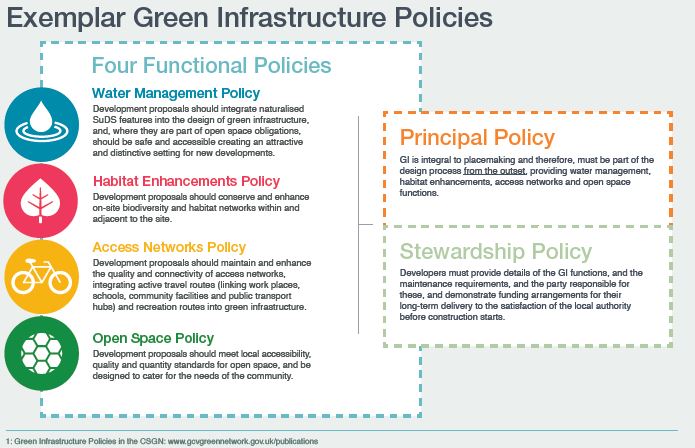
Planning for Green Infrastructure – Development Planning Policy Guide was produced by the partnership in 2021. This guide provides exemplar green infrastructure policies based on an analysis of development plan policies in central Scotland and is designed to maximise the benefits of green infrastructure to contribute to a successful place. These policy principles are generally addressed in East Dunbartonshire Local Development Plan 2 and Supplementary Guidance, in particular section 4.4 - Development management criteria for networks of green infrastructure - below.
The Green Network Blueprint, Glasgow & Clyde Valley Green Network 2019, is a framework for the creation of a strategic green network for the benefit of people and wildlife in Glasgow City Region. It incorporates the fundamental functions of a green network:
- A Strategic Access Network – facilitating the off-road movement of people around and between communities through green active travel routes and greenspace
- A Strategic Habitat Network – facilitating the movement of wildlife through the landscape, including bog and heath, wetland, neutral grassland and broadleaved woodland.
The Blueprint identifies for both networks:
- Existing green network assets that should be protected and managed
- Where there are gaps in the networks
- Opportunities to address those gaps.
The Blueprint will help to target resources and effort effectively, creating and enhancing the right green network component in the right place for most benefit. The focus is now on delivery through specific delivery initiatives focused on individual elements of the Blueprint, but also through the new development.
The Clyde Climate Forest was developed by the Green Network to deliver on the woodland element of the Green Network Blueprint’s Strategic Habitat Network. It will see 18 million trees planted in both urban and rural parts of Glasgow City Region over the next decade, increasing woodland cover in the region from 17% to 20%. Trees, woodlands and forests are recognised as essential if we are to address the climate crisis by reducing damaging atmospheric emissions and are crucial to assist in a recovery for nature. Broadleaved woodland in the region is fragmented due to urban development. The new planting aims to connect existing woodlands and help restore nature and boost biodiversity.
As part of the long-term plans, the Clyde Climate Forest project is asking community groups and land managers to help them identify places to plant new trees or replace ones that have been lost in the past. Work is also beginning to encourage smaller landowners and local authorities to gear up for tree planting. They are being offered free woodland assessments to help them identify potential new areas to be greened up with trees. The project is being delivered as part of the Glasgow & Clyde Valley Green Network, with support from Green Action Trust, The Conservation Volunteers (TCV), Glasgow City Region, Trees for Cities, Scottish Forestry and Woodland Trust Scotland.
Clyde Peatlands was created by the Green Network to deliver on the peatland element of the Green Network Blueprint’s Strategic Habitat Network. Peatland restoration is a nature-based solution to the climate and ecological crises. Healthy bogs can lock up and store large amounts of carbon, however, if degraded, they may instead emit more carbon than they remove.
Healthy, functioning peatlands can help mitigate the anticipated impacts of climate change, such as increased rainfall events, by storing and slowly releasing water back into the river network. Healthy peatlands are also home to an array of birds, plants, fungi, invertebrates and micro-organisms, making them an incredibly unique and biodiverse habitat. The Clyde Peatlands project directly addresses the opportunities for peatland restoration across Glasgow City Region with support and funding from NatureScot, through the Peatland ACTION Fund.
The Clyde Peatlands Project (and Clyde Climate Forest) has three elements:
Clyde Climate Forest and Clyde Peatlands have undertaken analysis that can be used to help target habitat management and creation through new development in East Dunbartonshire. This will include a target urban neighbourhood in each participating local authority to increase woodland canopy cover to 20%
Work continues on developing delivery initiatives for the other Blueprint elements - grasslands, wetlands and off-road active travel - but until these are in place, the Glasgow & Clyde Valley Green Network will provide support to East Dunbartonshire in identifying opportunities for green network and green infrastructure delivery through new development.
Clyde and Loch Lomond Flood Risk Management Strategy 2016 describes the agreed ambition for managing flooding and the priority of actions to be taken forward to deliver this. There is also a Local Flood Risk Management Plan for the Clyde and Loch Lomond area (2016) which provides additional detail on local responsibility, funding and co-ordination of actions. Taken together, these documents are the single point of reference for the public in describing the response and commitment of public bodies to address flooding. This Supplementary Guidance helps meet the objective of reducing flood risk by encouraging the provision of green infrastructure on development sites, in particular by provision of Sustainable Drainage Systems, protecting the flood plain and/or enhancing open space and the green network to provide natural flood alleviation.
The Glasgow City Region Forestry & Woodland Strategy 2020 is set to boost the number of trees in the region by a further 18 million over the next 10 years. Currently the region’s forests and woodlands cover around 60,000 hectares, but the strategy highlights that a further 9,000 hectares could be planted. This could result in 21% of Glasgow City Region’s land area being covered with a variety of trees by 2030. With more tree planting, the region has an opportunity to boost its efforts in tackling climate change.
The strategy has been developed by all eight local authorities within Glasgow City Region, Scottish Forestry, NatureScot and Glasgow & Clyde Valley Green Network Partnership. It sets out a positive woodland expansion vision for the next 10 years.
The strategy promotes the delivery of multi-benefit woodlands at the right scale and in the right locations whilst making a sustainable contribution to national expansion targets, including offering protection to non-woodland habitats. The strategy supports the development of the green network in Glasgow City Region and, in particular, the aims of the Clyde Climate Forest.
The strategy is aimed at those involved in planning, managing and developing forestry and greenspace in the public, rural and commercial sectors. Any woodland manager wishing to plant trees, or to apply for forestry grants in the future, will now be able to use the new woodland strategy to identify potential locations where forestry expansion could take place in the region. The Supplementary Guidance complements this strategy as native woodlands form part of the green network.
The Glasgow City Region Adaptation Strategy and Action Plan 2021 aims to ensure Glasgow City Region’s economy, society and environment is not only prepared for, but continues to flourish in the face of, the impacts arising from the climate crisis. The strategy:
- Outlines the processes and early interventions needed to manage climate risks and realise opportunities in line with our Theory of Change
- Provides a strategic framework for adaptation in and by the Glasgow City Region that fits alongside and supports key plans, policies and activities to enable delivery
- Encourages collaboration between citizens and organisations in realising the vision
- Sets out how progress in increasing climate resilience will be monitored and learnt from.
The strategy is supported by an action plan which contains the concrete actions being taken in the city region between 2020 and 2025 that will move us towards our vision.
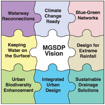
The Metropolitan Glasgow Strategic Drainage Partnership’s vision is...
To transform how the city region thinks about and manages rainfall to end uncontrolled flooding and improve water quality. This vision will deliver the partnership’s objectives through alignment with the partnership’s guiding principles, to sustainably drain the Glasgow City Region. The vision and objectives will be realised through collaborative working, shaped by the guiding principles - see diagram.
2.4 East Dunbartonshire Local Policy
East Dunbartonshire Local Development Plan 2 includes policies which apply to all types of developments. Policy 1 -East Dunbartonshire Development Strategy - identifies objectives for the plan's policies and proposals, which green network and infrastructure help deliver, and five green network strategic areas. Policies 2 to 8 and the Proposals Map identify the range of strategic green network locations in and around communities - incorporating assets, nodes and access/ habitat links.
Other polices which encourage green infrastructure include: 9 Climate Change, Sustainability and Energy Infrastructure; 10 Design and Placemaking; 11 Transport; 13 Community Facilities and Open Space; and 17 Natural Environment.
East Dunbartonshire Planning Guidance - including Supplementary Guidance on Design and Placemaking, Developer Contributions, Planning Guidance on the Natural Environment, Water Environment, and the Sustainability and Energy Statement Form - also supports Local Development Plan 2 policies and provides further local and detailed information of relevance.
Design and Placemaking Supplementary Guidance provides information on how to incorporate green infrastructure into development. It encourages the creation of high-quality places through a design-led approach and provides an overview of the planning application design process. This guidance includes detail on factors which should be considered in a site appraisal, encouraging the identification of characteristics and opportunities of a proposal at an early stage - looking at a site’s context, identity and connections. Key issues for consideration at site level of particular relevance to green infrastructure include: topography, hydrology and drainage, microclimate, wider green networks (habitat and access), landscape character, open spaces, existing biodiversity, and access for walking and cycling. The guidance contains a section on how to make it easy to move around a development, on foot or by bike. It also contains a section on how to protect and enhance the natural environment, including requirements for provision of open space, and how to deliver this using green infrastructure.
The Developer Contributions Supplementary Guidance (SG) sets out where developer contributions can be used and the tests for when they should be sought. It identifies how to determine the need for, and type of, developer contribution for housing and other types of development. It identifies where play space, open space and contributions towards the green network are required and the costs. The SG refers to the hierarchy of open spaces identified in the East Dunbartonshire Open Space Strategy 2015-20: open spaces of regional, neighbourhood and local importance.
East Dunbartonshire Green Network Strategy 2017-2022 sets the ambition, aims and objectives for the green network in East Dunbartonshire, and the local policy context, with a particular focus on biodiversity and access. It identifies and maps the green network on both a strategic, East Dunbartonshire-wide scale and a local, settlement scale, and presents opportunities and actions for improving the green network on both these scales. It places emphasis on partnership working and funding. This Supplementary Guidance sets out how developers are expected to take account of and respond to the Green Network Strategy when developing their own site-specific proposals.
The Sustainability & Climate Change Framework Action Plan was approved in December 2019 and updated in September 2021. Work is also underway to deliver a range of actions to tackle climate change in East Dunbartonshire and fulfil our sustainability ambitions. A progress report on the delivery of the action plan between December 2019 and March 2021 was approved in September 2021.
Emerging local East Dunbartonshire policy and strategy
Early engagement has taken place regarding the Climate Action Plan and Greenspace Strategy, and consultative drafts of the strategy and action plan are being prepared. This will provide the local policy context for delivering the actions specified in the Climate Change Plan Update and new Scottish Biodiversity Strategy (referred to in the national policy section) and also the Glasgow City Region priorities, referred to in the regional policy section. The Climate Action Plan and Greenspace Strategy will integrate with the Clyde Climate Forest, Clyde Peatlands and the wetlands initiative to identify opportunities for nature-based solutions to climate change, to increase resilience to the effects of climate change and to provide an important source of carbon removal. Nature-based solutions and carbon removal are core themes for addressing the climate change and nature crisis identified in NPF 4. This emerging policy demonstrates that there is an urgent need to ensure that green networks and green infrastructure are designed in a way that supports our climate action and biodiversity objectives.
3 What is the East Dunbartonshire Green Network?
3.1 Benefits of the green network
The Green Network Strategy states that the green network, when of high quality and well connected, can provide a number of benefits for people and nature. Investing in our green network will ensure we receive these benefits now and in the future.
- Improving the quality of our surroundings by providing high-quality places, making East Dunbartonshire a more desirable place to live, visit and do business.
- Improving our physical and mental health and wellbeing by encouraging more people to increase their activity levels through better access to attractive and enjoyable natural spaces, which provide opportunities for active travel, play, outdoor sport and recreation, relaxation and reflection.
- Helping us to adapt to and mitigate climate change through natural flood alleviation, carbon sequestration and creating habitat connections to enable wildlife to migrate.
- Enhancing biodiversity by improving linkage for wildlife between habitats.
- Supporting sustainable economic growth by providing an attractive setting for investment and a landscape framework for communities and businesses to grow.
- Providing inspirational places for outdoor volunteering, education and training.
- Providing an environment for community growing and local food production.
3.2 The existing East Dunbartonshire Green Network
East Dunbartonshire’s natural environment is at the heart of what makes it a special place to live, work and visit. The majestic Campsie Fells, the lowland river valleys, pockets of native woodland and the numerous parks, open spaces, green spaces and paths within and around settlements all help define East Dunbartonshire as the place it is today. Together they form a valuable and essential green network which contributes to and enhances quality of place, and the prosperity and wellbeing of the area’s residents, workers and visitors.
In East Dunbartonshire the term 'green network' encompasses both land and water (sometimes called the blue network). It encompasses open space and natural/semi-natural habitats, and the paths and habitat corridors that connect them. It creates connections for wildlife which allow for the movement of species through the landscape and urban areas. The green network is also a resource of open space and paths for residents, workers and visitors to use for recreation and active travel.
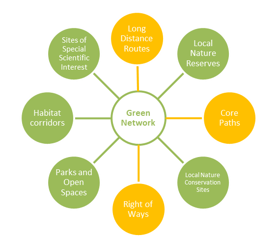
The green network as it currently exists in East Dunbartonshire can be thought of as having a series of key components consisting of nodes of open space, geological features and habitat such as parks, Sites of Special Scientific Interest, Local Nature Reserves and Local Nature Conservation Sites connected by linkages and access routes such as core paths, rights of way and linear stretches of habitat corridors - including watercourses, hedgerows, and vegetated road and rail verges. The main components that together make up the green network are shown in Figure 5 below.
3.3 The green network: strategic and local
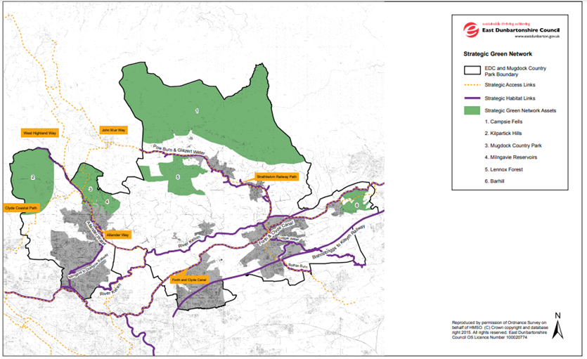
The green network components can also be split into strategic and local elements depending on their location and size. The green network does not stop at the Council boundary and those elements of the green network that are cross boundary, link settlement areas within East Dunbartonshire or are of a size and scale to attract visitors from throughout the council area and beyond are identified as part of the Strategic Green Network. This strategic network is integral to the area’s heritage and identity. It consists of larger areas of greenspace, mostly within the rural environment, and cross-boundary access links and habitat corridors (see Annex A).
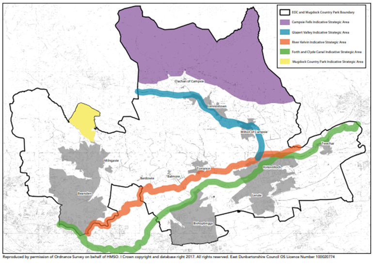
The Green Network Strategy identifies five key areas within the Strategic Green Network where large, landscape-scale intervention would deliver on all objectives of the strategy. These are reflected in the City Region’s Green Network Blueprint. The East Dunbartonshire Green Network Strategy will be replaced by the emerging Greenspace Strategy, which places greater emphasis on nature-based solutions to climate change.
The Developer Contributions SG states that a development of 50 dwellings or more is required to contribute to a green network opportunity and/or the upgrade or improvement of an open space of regional importance within 2km of their site, which is within cycling distance. This is dependent on whether there are projects ongoing or programmed - such as for any relevant Green Network Strategic Area - to which a contribution can be made. There are different Strategic Green Network assets or links within 2km of each of the settlements in the area (see Annex A). The five green network strategic areas identified in the Green Network Strategy are: the Campsie Fells, the Glazert Valley, the River Kelvin, the Forth & Clyde Canal and Mugdock Country Park (see Annex B).
The Local Green Network is located mainly within the urban environment and consists of the open space and path networks that people use when making local journeys or in their everyday lives for activities such as play, sports, recreation and relaxation. These spaces and connections are important to people that live or work near them. These spaces also provide habitat for wildlife, including protected species, creating better places for people and nature. They also provide opportunities for climate change mitigation and adaptation, such as shelter, shading and Sustainable Drainage Systems (SuDS).
Some green network components are of importance on both the strategic and local scale. The LDP2 Community Policies and Proposals Map shows the green network within each of the community areas in East Dunbartonshire
3.4 The aspirational green network
The Green Network Strategy identifies the aspirational green network by identifying physical gaps in the network and known low-quality components within the existing components of the green network (Green Network Strategy, paragraph 3.3). It maps these gaps and components of known low quality, including a table which lists the access link gaps, and identifies strategic and local green network opportunities to address issues of quality. This is based on the most current information at the time of writing the Green Network Strategy and will be reviewed and updated. Development should enhance the green network by contributing to access links which fill/improve these gaps, and improve green network hubs and habitat links of known low quality.
4 Delivery of networks of green infrastructure in development
4.1 Green network opportunities related to development
The LDP2 Community Policies 2 to 8 identify green network opportunities in a range of sections including:
- For Place (Locality) Plan projects
- Community facility and open space projects
- Town centre actions
- Key requirements for regeneration masterplan areas
- Key requirements for proposed development opportunities in business and employment sites
- Policy for key tourism assets
- Key requirements for housing allocations
- Key requirements for brownfield sites
- Transport projects.
These include opportunities for development to enhance habitats for biodiversity, to improve poor-quality open space and to provide or upgrade access to open space. Any masterplans or site briefs for these sites should also inform planning applications by setting out more detailed site-specific considerations, and requirements for green infrastructure and opportunities to enhance the green network. Green network opportunities will predominantly be delivered on the development site, with some improvements to the wider green network, in line with the Developer Contributions Supplementary Guidance. The emerging Greenspace Strategy will assess green network opportunities in relation to new development.
4.2 The role of development management
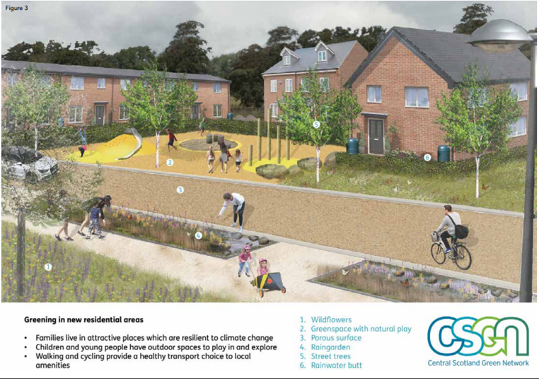
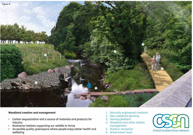
The planning system is one of the most important means of delivering the green network. It can ensure that development respects, enhances and expands the existing green network. It can also help ensure that the right kinds of green infrastructure are created in the right place and that the widest possible range of benefits are secured. Quality green infrastructure has the potential to improve and enhance most developments and it should be a key consideration under any topic area, see Annex C, Central Scotland Green Network Illustrations - Greening in New Residential Areas and Woodland Creation & Management. Development management delivers green infrastructure and supports the green network by promoting, safeguarding and enhancing these, and promoting a multi-functional resource.
Development proposals will promote, safeguard and enhance the network of green infrastructure as a key contributor to placemaking and the enhancement of local distinctiveness. Green infrastructure in all its forms has a key role to play in reinforcing the character and quality of urban and rural landscapes. It can relate an individual site to its environmental context and help emphasise key habitats and access links. Placemaking is central to enhancing the environmental and economic quality of East Dunbartonshire, and perceptions of the area among investors, potential employees and visitors. This requires that green infrastructure and the green network are considered and integrated from the outset. Short-term and temporary greening of future development sites can be as important as longer-term solutions. The planning system therefore has a key role to play in delivering the placemaking agenda.
Development proposals will promote the development of multi-functional networks of green infrastructure. Including multi-functional green infrastructure which delivers multiple benefits is an efficient use of land. Sustainable Drainage Systems (SuDS), for example, can be designed to provide a range of recreational opportunities, and landscape and biodiversity benefits in addition to their primary purpose of surface water management. Equally, the creation of new green infrastructure can help promote community involvement, active travel, healthier lifestyles and biodiversity. This in turn provides new opportunities for local people to become involved in volunteering, training initiatives and, ultimately, employment.
The Building for Nature qualitative benchmark [opens in a new window] scheme for blue-green infrastructure can help ensure that all involved in design, delivery and maintenance are clear as to what is expected. The benchmark requires the consideration of standards relating to water, wellbeing and wildlife in a spatial context in terms of what they contribute to that place and wider connectivity.
4.3 Requirements for delivery of networks of green infrastructure
Development proposals are required to take account of the following principles through the planning application process:
- A network of green infrastructure will be integrated into the design process for all developments from the outset, based on discussion with stakeholders. A wide range of scales of development presents an opportunity to deliver this. Green infrastructure design elements will be considered from the outset as an equal and integral part of the development design process. This is better than addressing these issues once other elements of the scheme have become ‘fixed’.
- Planning for a network of green infrastructure must be based on an understanding of place, character, local assets, need and opportunities, informed by site context appraisal and spatial analysis. Development proposals will consider the context beyond the boundary of the development site. This will help to create a more co-ordinated and joined up green network. Geographic Information System (GIS) information on the green network (strategic and local access links, and habitat nodes and links) is available to contribute to the assessment of a development proposal, on the LDP2 Proposals Map (interactive GIS). This information will inform site-based appraisals, assessments and surveys. For more information, visit Local Development Plan 2.
- Development proposals which would result in the loss or fragmentation of existing green network components will be assessed against Policy 20 (Green and Blue Infrastructure) of National Planning Framework 4. Applicants will be expected to undertake ecological surveys and appraisal in line with CIEEM guidelines prior to submitting a planning application. Where surveys identify that development is likely to affect the green network, a full Ecological Impact Assessment should be undertaken in line with CIEEM guidelines. East Dunbartonshire has good green network connectivity, but there is considerable scope for the network to be enhanced and strengthened. The design of new development has an important role to play ensuring that it contributes to the quality of the network and enhances access and habitat links, while preventing any loss or fragmentation of the network.
- The quality and function of a network of green infrastructure, and how it will be sustained and maintained in the long term, will be considered from the outset. A green network can deliver a range of benefits, including opportunities for recreation, play and active travel, habitat connectivity, and climate change adaptation and mitigation. However, without careful consideration being given not only to the design, but equally importantly the future management and maintenance of green infrastructure at the outset, the range of benefits will reduce quickly over time. Early cross-stakeholder consideration of funding and management mechanisms for the effective long-term management of blue-green infrastructure will prevent many of the problems associated with the quality of green infrastructure, including open spaces, in particular by asking for management and maintenance plans.
4.4 Devlopment management criteria for networks of green infrastructure
LDP2 Policy 10 Design and Placemaking states that green infrastructure must be considered as an integral element of placemaking and form a key part of the design of new developments. It should integrate effectively and coherently with the green network immediately surrounding the site and with wider habitat, access and greenspace networks. Wherever possible, opportunities should be sought to create a new link or enhance an existing one. On-site green infrastructure should be multi-functional in nature.
Proposals will demonstrate how the green network and green infrastructure have been considered from the earliest stages of the developers design. This process will be set out in a Design and Access Statement, particularly for housing proposals of more than 50 units.
Detailed criteria to ensure a development proposal delivers high-quality green infrastructure and the protection and enhancement of the green network are set out in Table 3. A planning application is required to address these criteria.
Development proposals which would result in the loss of outdoor sports facilities or children’s outdoor play provision will also be assessed against the relevant criteria of NPF4 Policy 21.
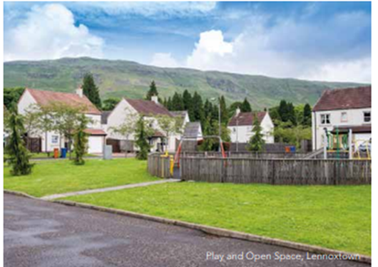
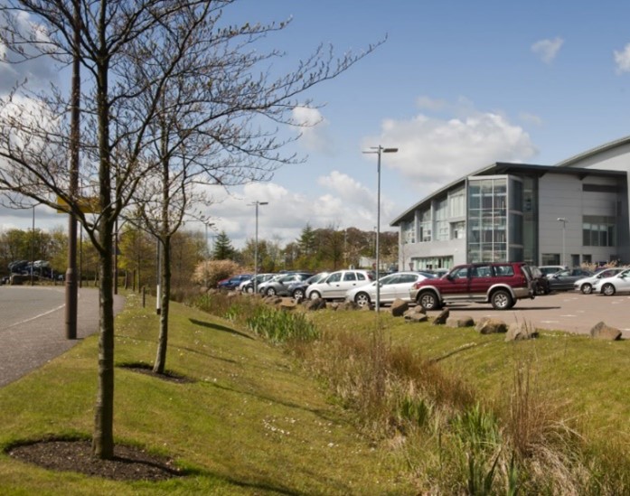
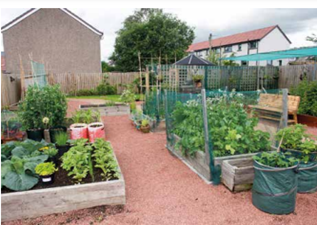
Table 3 - Development management criteria for networks of green infrastructure
| Planning applications are required to demonstrate that the proposed development protects, enhances, expands and creates a network of green infrastructure by: |
|---|
| Placemaking |
|
|
|
| Biodiversity |
|
| Planning applications are required to demonstrate that the proposed development protects, enhances, expands and creates a network of green infrastructure by: |
|
|
| Promoting, health and physical activity |
|
|
|
|
| Planning applications are required to demonstrate that the proposed development protects, enhances, expands and creates a network of green infrastructure by: |
| Sustainable drainage |
This includes ensuring a network of green infrastructure is able to contribute to future changes and expansion for climate change adaptation. Integrate areas with potential for natural flood alleviation into the landscape framework. |
|
| Maintenance & Management |
|
|
5. Good practice examples of green infrastructure
These include planning permissions for developments which protect and enhance or create green infrastructure, including a natural Sustainable Drainage System scheme, enhancement of an existing burn and wet grassland or management of significant/TPO trees during construction.
5.1 Creation of natural Sustainable Drainage System – Kessington
A housing development for 59 units at Kessington, Bearsden, was approved in March 2016. This development provided a natural wetland Sustainable Drainage System in the green belt adjacent to the site. This provides natural flood alleviation, creates recreational open space, enhances the setting of the development and wider settlement (as houses face onto it) and creates an enhanced footpath link into the adjacent Templehill Woods Local Nature Conservation Site (LNCS).
5.2 Tree protection – Kilmardinny
There was a very good example of tree protection during the construction of 135 detached and terraced dwellings on the former Bearsden Bus Garage site, Bearsden (Approval Of Matters Specified In Conditions application). This forms part of the Kilmardinny Master Plan. In partnership with Envirocentre, the site agent and Council officers worked closely together to prevent damage to trees to be retained as part of development proposals. The retained trees were afforded the right protection during construction works. This was challenging due mainly to the installation of utility services. However, on the majority of occasions, a solution was found that suited all parties.
5.3 Enhancement of burn and wet grassland habitat - Braes of Yetts
A proposed development of 123 houses at Braes of Yetts, Kirkintilloch, had its Approval of Matters Specified in Conditions granted subject to conditions in March 2017. Further information provided included an ecological report, a habitat management plan, and an otter and vole survey.
The design will conserve and enhance the natural habitats of wet grassland, road-side hedgerow and a burn adjacent to the Merkland Local Nature Reserve, which form part of the countryside setting of Kirkintilloch. As part of the development, locally-suitable grassland, scrub and trees will be planted to provide a new green belt boundary to the east, including native species. The Black Burn will be maintained and enhanced in a wildlife corridor of locally-suitable grassland, scrub and trees through the housing area, with a ledge in the design of a culvert to allow mammal passage along the burn. In addition the proposal will locate Sustainable Drainage System and play areas adjacent to the grassland area, and create a footpath connection link across the northern boundary of the wet grassland which will also link the Local Nature Reserve to a core path in the open countryside to the east.
5.4 Management of significant trees during construction - Greenhead Road
In Greenhead Road, Bearsden, planning permission was granted subject to conditions in August 2016 to demolish the existing bungalow and build two new properties within the site. An amendment to this was also granted to include an extension and car parking, granted subject to conditions in February 2017. This is a small-scale development and appropriate tree protection measures are in place to protect trees which are subject to a TPO. The conditions required a pre-start meeting prior to commencement of construction activities with the site agent, arboriculture consultant and Council officers to discuss: the position of tree protection barriers around retained trees; and the roles and responsibilities of each party during construction activities on-site. The conditions are needed to ensure that the applicant complies fully with the necessary tree protection measures. This has been found to be an important way of communicating responsibility for tree protection to contractors and ensuring that it takes place.
Another condition requires that prior to work commencing on site an arboricultural method statement should be submitted, relating to construction activities within the root protection area of the protected trees on the site. The reason for this is to ensure that the root protection area of the trees is protected during the construction period.
5.5 Provision of open space and Sustainable Drainage System pond – Lumloch Drive, Bishopbriggs
Outline planning permission was granted for approximately 400 houses on an eight-hectare site in 1992. The planning permission included provision of a 3.5ha open space with residential development to the north and south, and phase three of the Bishopbriggs Relief Road to the east. The open space includes a play area, multi-use games area, seating areas, areas of tree planting and a naturalised Sustainable Drainage System pond in the south. There are paths throughout the open space and it is linked to off-road paths to the north and south. The park and pond form an extension to an existing open space at Angus Avenue, to the west, which is part of an existing residential area. The pond was sited on a low area which originally had a drain running through it.
5.6 An extension with a green roof – 18 Roman Road, Bearsden
The extension at 18 Roman Road (ref TP/ED/15/0285) includes an innovative green roof made of sedum. This provides the extension with an innovative design as the green roof adds a natural material and texture to the exterior of the house, acts as natural Sustainable Drainage System and when viewed from the house forms a green area that complements the garden, as well as providing biodiversity interest.
5.7 Woodhill and Etive Climate Ready Parks
This is a multi-functional project led by the Council’s Greenspace service which includes various measures to improve drainage as well as other improvements including play facilities, biodiversity planting, traffic calming and community food growing; and is an example of how project’s can incorporate the principles of the Metropolitan Glasgow Strategic Drainage Partnership.
6 Further Information
6.1 Publications which provide further information:
National Policy & Guidance
Scottish Government
Getting the Best from Our Land - A Land Use Strategy for Scotland
Let's Get Scotland Walking: The National Walking Strategy, 2014
Planning Advice Note 65: Planning and Open Space
Play Strategy for Scotland: Our Action Plan, 2013
Water-resilient places - surface water management and blue-green infrastructure: policy framework, 2021
Scottish Government publications [opens in a new window]
- Green Infrastructure: Design and Placemaking Guidance, 2011 [opens in a new window]
- Scotland’s Climate Change Plan, 2020 [opens in a new window]
NatureScot
- (Formerly Scottish Natural Heritage) 2014, Urban Green Infrastructure Benefits Factsheet
- (Formerly Scottish Natural Heritage) Information on Green Networks Susdrain Information on Sustainable Drainage
SEPA
- The Water Environment Hub
- SEPA Planning advice [opens in a new window], including SEPA Triage Framework: Guidance for planning authorities on how and when to consult SEPA
Scottish Forestry
- UK Forestry Standard, 2017 [opens in a new window]
- Scotland's Forestry Strategy 2019 to 2029 [opens in a new window], Scotland's Forestry Strategy Implementation Plan 2020 to 2022
Other
- Association of Local Government Ecologists [opens in a new window]
- British Standard on biodiversity management (BS 42020)
- Fields in Trust 2020, Guidance for Outdoor Sport and Play [opens in a new window]– Beyond the Six Acre Standard (Scotland)
- Building with Nature, benchmark scheme for blue-green infrastructure [opens in a new window]
Glasgow City Region Policy & Guidance
- Climate Ready Clyde, Glasgow City Region’s Adaptation Strategy and Action Plan, 2021 [opens in a new window]
- Glasgow and Clyde Valley Green Network Partnership [opens in a new window]: Green Network Strategy for the Glasgow City Region, 2017
Our Blueprint, 2021
Planning for Green Infrastructure, 2021 - Metropolitan Glasgow Strategic Drainage Partnership Vision, Objectives and Guiding Principles [opens in a new window]
- SEPA, Clyde and Loch Lomond Flood Risk Management Strategy [opens in a new window]
- Central Scotland Green Network [opens in a new window]
East Dunbartonshire Council
- Proposed Local Development Plan 2 2020
Proposed Local Development Plan 2 - Design and Placemaking SG, 2022
Developer Contributions SG, 2022
Natural Environment Planning Guidance 2018
Sustainability and Energy Statement Form 2020
See links above - Sustainability & Climate Change Framework (SCCF) Action Plan Updated 2021
- Climate Action Plan (CAP)
- East Dunbartonshire Open Space Strategy 2015
Green Network Strategy 2017 to 2022
Greenspace - Active Travel Strategy, 2015
Core Path Plan,
Local Transport Strategy, 2020
Transport
6.2 Contact
Planning applications should be submitted using the online portal ePlanning.scot
More information can be found on the planning application section of the website and
eplanning.scot/ePlanningClient [opens in a new window]
The Development Management Team can also be contacted by email and telephone for pre-application advice:
Email: planning@eastdunbarton.gov.uk
Tel: 0300 1234510
7 Annexes