Masterplan Summary
- Driving Economic Development and Local Jobs for East Dunbartonshire
- Vision
- Planning and Sustainability
- Delivery
Driving Economic Development and Local Jobs for East Dunbartonshire
Situated on the edge of the Glasgow City conurbation and set in some of the most scenic landscapes of the Glasgow City Region, East Dunbartonshire is a well-connected and desirable area. It boasts of a highly skilled work force, some of the top schools in the country, highly desirable neighbourhoods, served by a range of good quality town centres and is accessible to a range of outdoor and leisure facilities. These strengths in turn provide an excellent location for investment and to do business, for employees and those choosing to live close to their place of work.
The Westerhill Regeneration Area Masterplan site encompasses approximately 300 hectares and is bordered by the A803 to the west, the Antonine Wall World Heritage Site to the north, and a national railway line to the south and south-west. The site is well situated, only 5 miles from Glasgow City Centre and the River Clyde and approximately 20 miles from Glasgow Airport. It is located 2 miles north of the M80 and Bishopbriggs Town Centre.
The need for the Masterplan is highlighted in the adopted East Dunbartonshire Local Development Plan 2 (LDP2) and is required to address limited access to higher earning employment within East Dunbartonshire, low job density and low economic output (GVA), and to unlock larger economic development sites through increased business land supply.
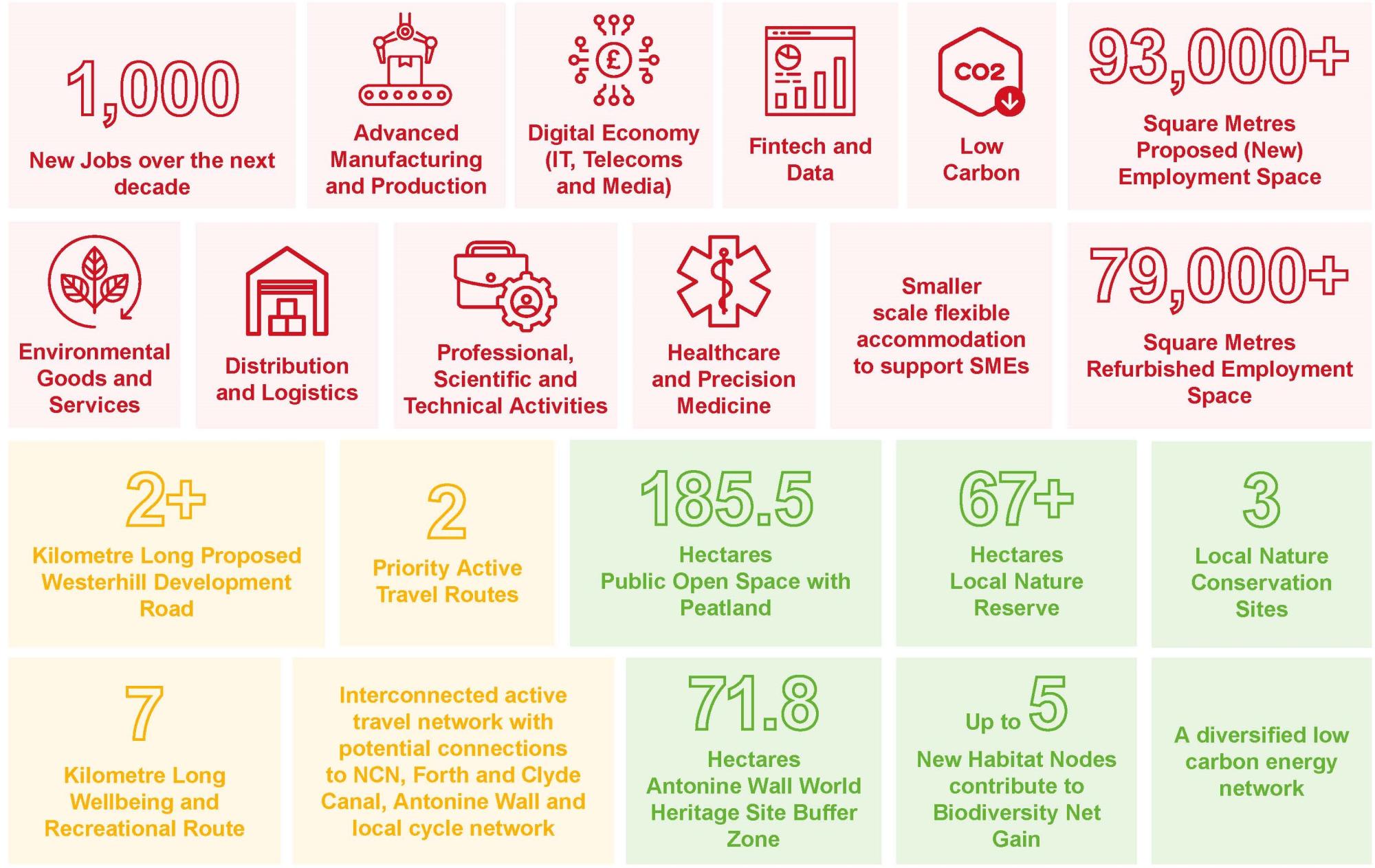
The Framework Masterplan aims to create accessible employment land that will direct future growth, attract new investment and deliver long term employment opportunities in the local area and wider City Region. The Masterplan proposes flexible developable land parcels to support regional and national priority sectors and potential local growth opportunities, supported by public sector transport infrastructure investment, which can be taken forward over time.
The Masterplan also aims to contribute to the transformation of Bishopbriggs to become a 20-minute neighbourhood with access to local jobs, good sub-regional, local and internal sustainable travel connections and high quality environment to operate and work in, while actively contributing to the Scottish Government’s net-zero carbon targets by 2045.
The ‘policy thread’
The National Planning Framework 4 (NPF4) and the adopted LDP2 provide the formal Development Plan policy context at national and local level, and together with relevant regional and local economic development strategy (notably the Glasgow City Region Economic Strategy and East Dunbartonshire Economic Development Strategy) guide the development and economic strategy for the WRA Masterplan and associated delivery plan.
The Masterplan approach is consistent with the East Dunbartonshire Place & Growth Programme (for Bishopbriggs) articulated through the approved City Deal Strategic Business Case 2020. LDP2 recognises that mixed use development provides many benefits both in terms of design and function - creating places that are sustainable and accessible. Policy 3.R states that development in Westerhill will deliver employment uses (Use Classes 4, 5, 6 and 11) to regenerate brownfield land, deliver employment growth, and provide a green network and improved transport links.
The Framework Masterplan fully aligns with the policy requirements set forth in the NPF4 and LDP2 to deliver a long term vision that will shape development and encourage investment, support local living across Bishopbriggs and Auchinairn communities, protect the natural environment and embody sustainability and climate resilience. The Masterplan is formal planning guidance under the adopted LDP2.
It will be a material consideration when determining planning applications for any proposals within the Westerhill Regeneration Area.
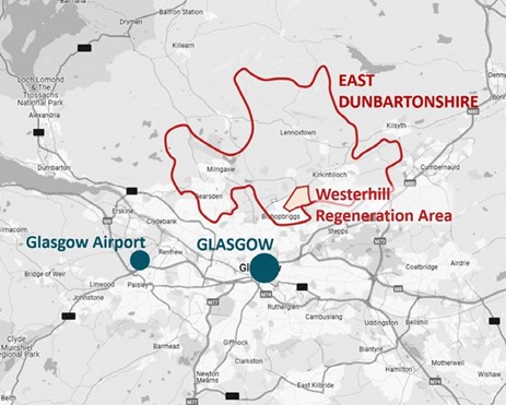
Figure 1. Westerhill Regeneration Area location
Vision
A collaborative and deliverable vision has been shaped for Westerhill Regeneration Area and is as follows:
‘ Set in one of the most desirable local authority areas in Scotland ( East Dunbartonshire), the Westerhill Regeneration Area is an attractive andaccessible investment location providing long- term opportunities for business, economic and inclusive growth’
The delivery of the vision is supported by eight (8) placemaking objectives with their respective design principles which are as follows:
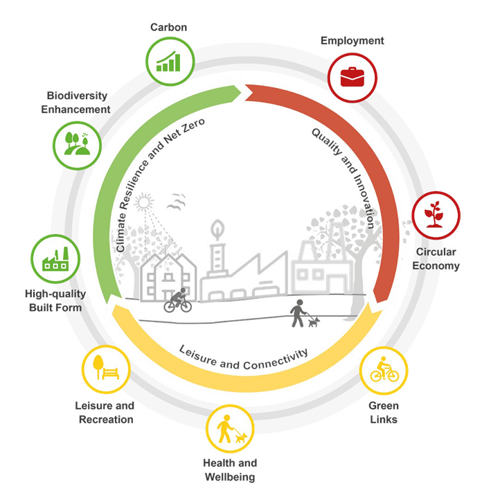
Figure 2. Westerhill Regeneration Area Placemaking Objectives
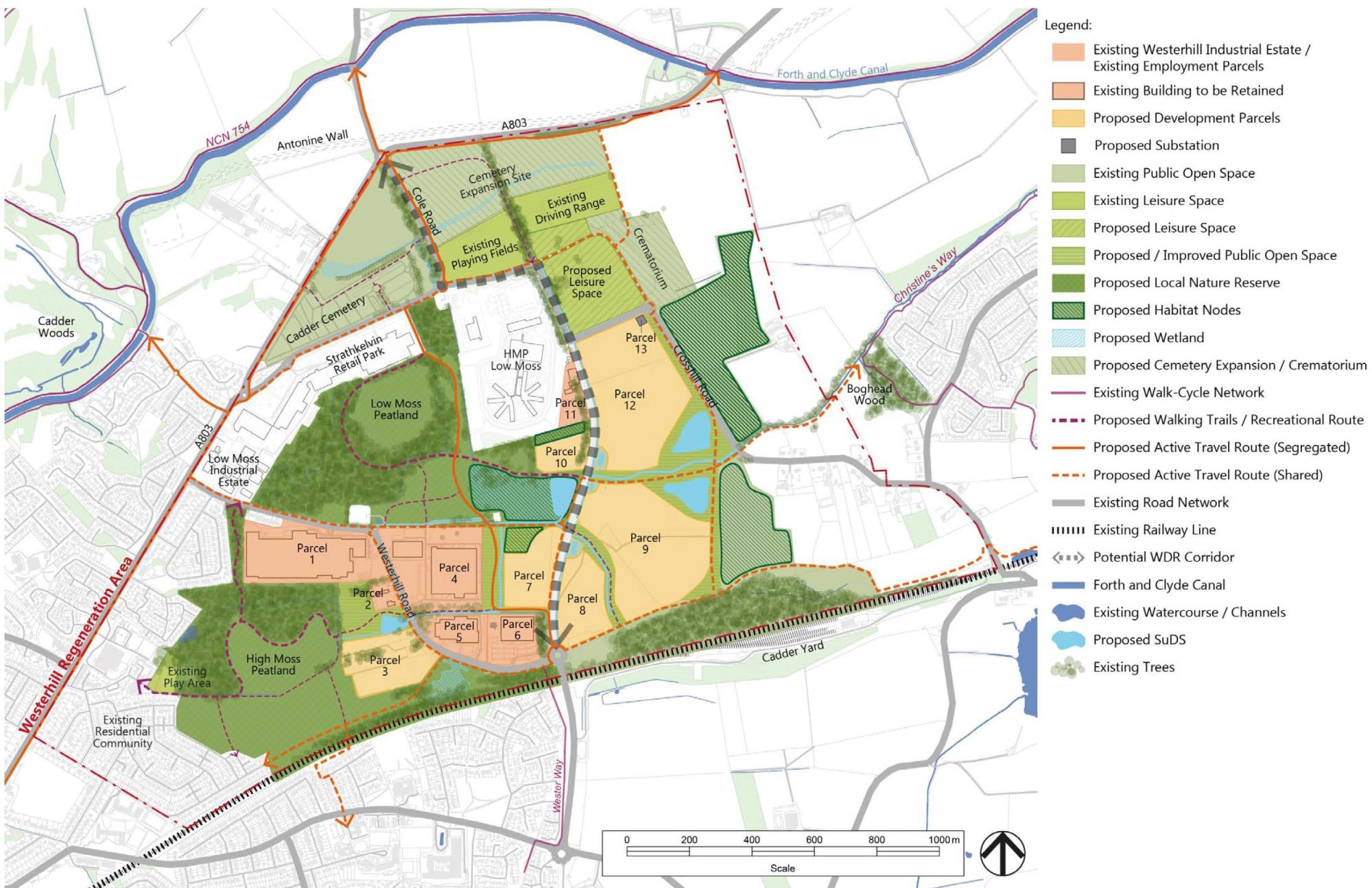
Figure 3. Westerhill Regeneration Area Framework Masterplan
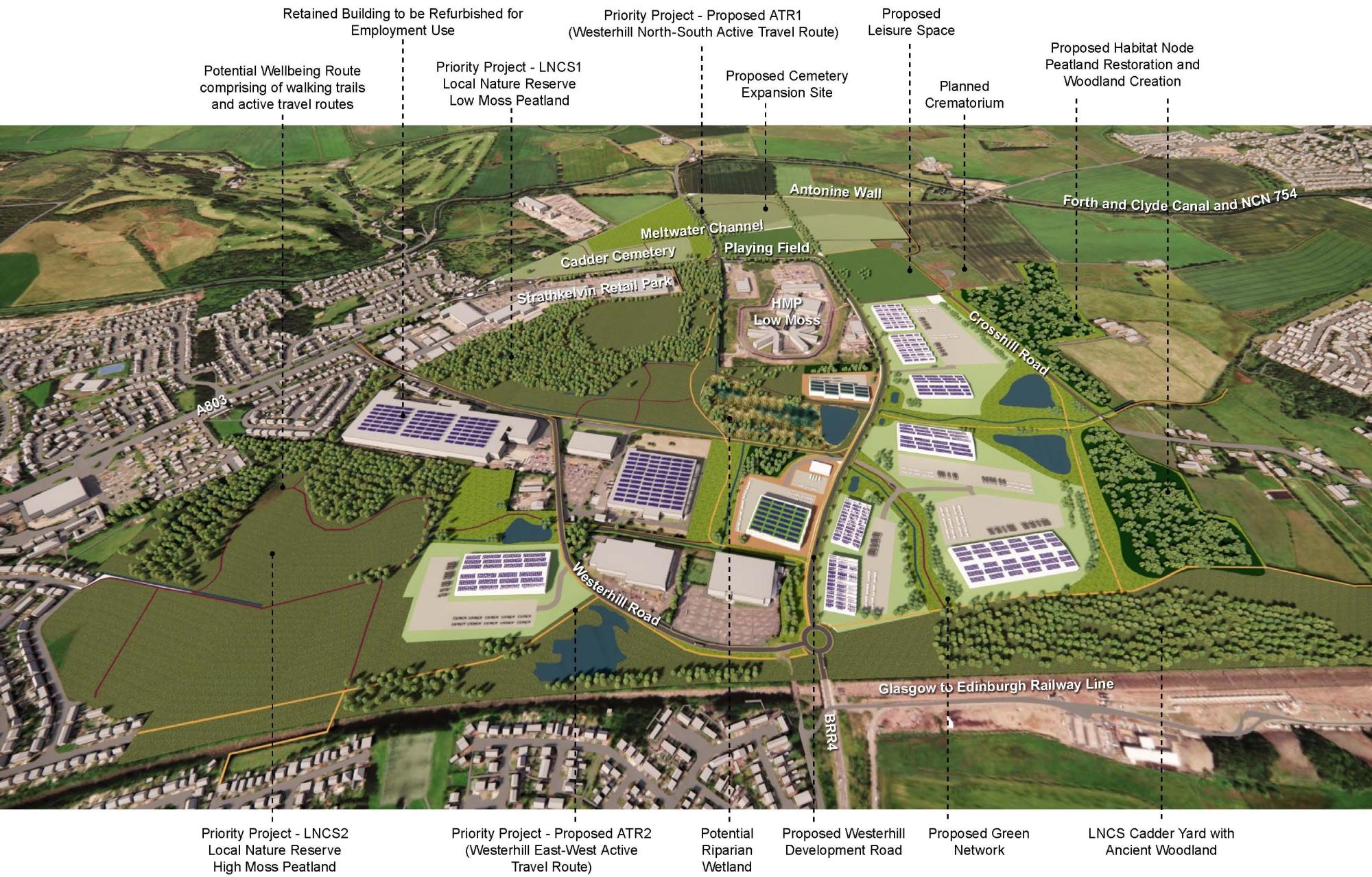
Figure 4. Westerhill Regeneration Area Masterplan - Illustrative Aerial View
Planning and Sustainability
The Masterplan embeds an Environmental Sustainability Plan (ESP) which provides guidance and sets target for future regeneration. The ESP is framed and guided by national, regional and local policies including the NPF4, Scottish Planning Policy (SPP), Climate Change (Scotland) Act 2019, Scotland National Peatland Plan, East Dunbartonshire Sustainability and Climate Change Framework (SCCF), East Dunbartonshire Local Heat and Energy Efficiency Strategy (LHEES) and the East Dunbartonshire Local Development Plan.
The ESP adopts a holistic approach to sustainability to deliver improved sustainability performance, contribute to the Scottish Government’s objectives to achieve net zero carbon by 2045 and identify opportunities to enhance Westerhill’s value during Masterplanning stages.
The ESP includes guidance in the form of Key Performance Indicators (KPIs), targets and recommended actions to address the following components:
- Diversified low carbon energy solutions, delivery of energy efficient buildings and minimising construction waste
- Building with nature for nature recovery through peatland conservation and habitat creation, biodiversity net gain and improvement to local health and wellbeing.
- Water management including sustainable consumption
- Sustainable transport modes with alternatives
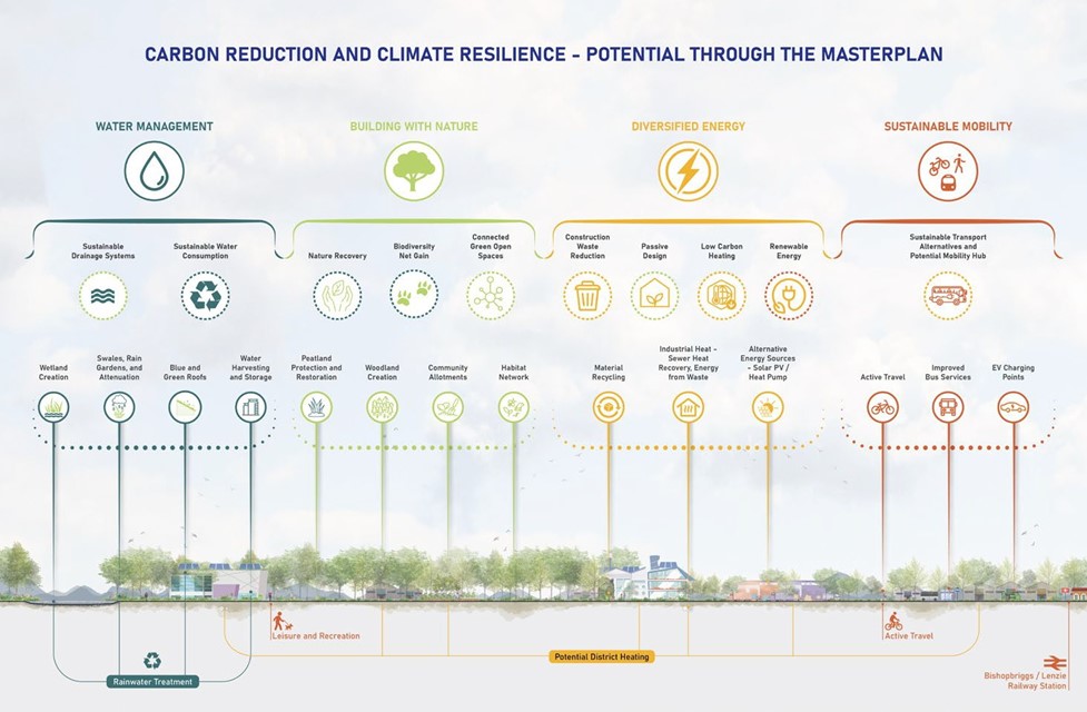
Figure 6. Westerhill Regeneration Area Sustainability Approach
Delivery
The delivery of WRA Masterplan will require a long-term approach to development. This is triggered through land release and re-designation supported by planning policy, and public sector investment in transport infrastructure (proposed WDR).
The Council and any relevant public sector partners will work with the landowners to bring forward potential development. The Masterplan is Planning Guidance and forms a material consideration for future development applications within the area.
Based on the economic analysis and market research carried out in the preparation of the Framework Masterplan, it is anticipated that delivery of proposals will advance in three (3) stages, consistent with the overall framework for development. Although these stages are not prescriptive, development is envisioned to progress as detailed below.
|
Delivery Stage |
Land Parcels |
Activity |
|---|---|---|
|
2023 - 2031 |
Parcels 1, 2, 4, 5, 6 and 1 |
Promoting existing businesses and brownfield land development. Delivery of the WDR. |
|
2026 - 2035 |
Parcels 3, 7, 8, 9 and 10 |
Economic growth through delivery of high-quality jobs on newly released development land. |
|
2035 onwards |
Parcel 12 |
Future land reserve and future promotion. |
The Masterplan provides flexibility in relation to how sites are developed in more detail and subsequently brought forward through the planning process. Mini masterplans, for example, could be presented for one or more land parcels. This process would support a more manageable development scale and avoid a larger, over ambitious, detailed development application for the whole of the WRA. Planning Permission in Principle applications (with follow on Approval of Matters Identified in Conditions), or detailed Planning Applications may present the best solution dependent on the specific delivery arrangement and requirements of the site and end user.
Delivery, implementation and stewardship responsibilities of plot-level amenity space, ecological corridors / green networks through parcels, flood risk, sustainable drainage solutions, access to sustainable transport and parking, grid capacity, additional secondary and tertiary streets, and active travel connections, lies with the landowners/developers and must be demonstrated through the planning application process.
EDC’s City Deal Place and Growth Programme will fund the development of the WDR. It is anticipated that the following priority sustainable green and active travel projects will be funded through various Planning Legal Agreements associated with the development of the land identified as parcels within the Framework Masterplan.
- Achieving Local Nature Reserve (LNR) status for the Low Moss and High Moss Local Nature Conservation Sites (LNCS)
- Establishing two main effective and efficient north-south and east-west active travel routes (ATR).
Supporting future green networks, open space, and sustainable travel projects have been identified through the delivery of the Framework Masterplan and should be taken into consideration where required. These projects will aim to maintain and enhance the exceptional environmental assets, provide leisure and recreation facilities and enable sustainable connections to the local and regional employment market. They are subject to further investigation, feasibility assessments and exploration of funding from other sources.
The Masterplan sets the context for development, beyond the period of LDP2, as a strategic framework guiding future development, consistent with the core principles of NPF4.
LDP2 policy 3.R and its subject policies provide the necessary policy checks and balances against which any new individual development proposals will be assessed. Key policy designations and requirements of LDP2 are clearly set out relating to the need for, quality in design, technical and environmental requirements, sustainability, accessibility, and infrastructure requirements.
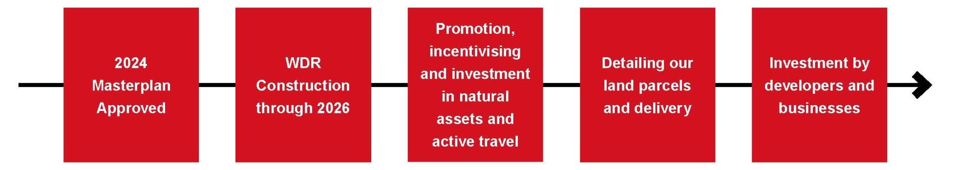
Figure 7. Key Moves and Timeline