Westerhill Development Road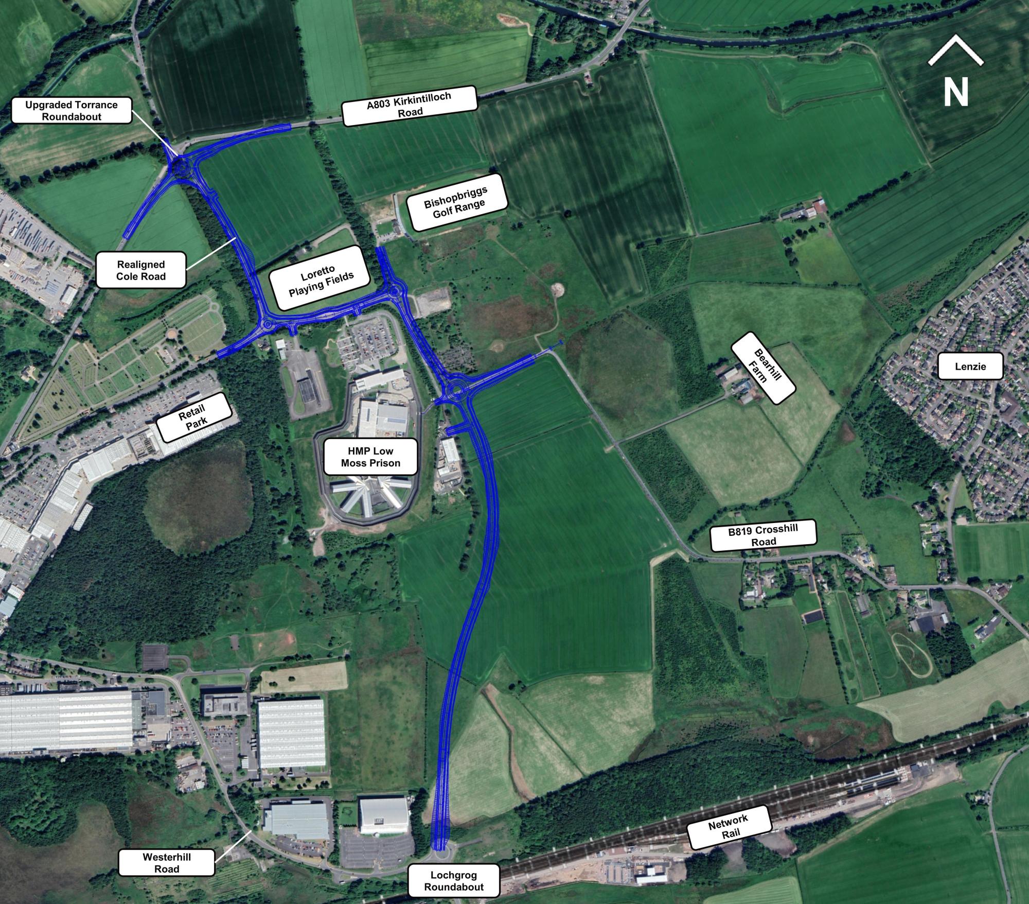
This project element of the Council’s City Deal Place and Growth Programme includes the delivery of the Westerhill Development Road (formerly known as Phase 5 of the Bishopbriggs Relief Road) to complete the route through East Dunbartonshire and Glasgow north, improving connectivity and unlocking strategic development sites to enable follow on investment.
The delivery of the Westerhill Development Road (WDR) will:
- Remove non-essential traffic from travelling through Bishopbriggs
town centre - Alleviate issues in relation to the Air Quality Management on A803
- Enable A803 corridor improvements
- Enable a well-connected workforce within East Dunbartonshire and wider city region
- Promote improved road infrastructure coupled with sustainable travel options, particularly for commuting journeys
- Help enable development of derelict/vacant land to ensure there is space for local companies to grow, to attract other high quality businesses and reduce barriers to jobs locally.
Development of potential routes for the WDR is being aided by the creation of a Masterplan and Environmental Report for the Westerhill Area. Both the Masterplan and the Environmental Report are being developed in tandem and will play a crucial part in identifying the potential of this area to contribute to the economic regeneration of Bishopbriggs.
For more information, visit the Westerhill Regeneration Area Framework Masterplan webpage (link opens in new window).
Consultation
Consultation took place on options for the new Westerhill Development Road between 29 May and 22 June 2023.
There were five options for a new stretch of road starting from the Lochgrog Roundabout (Phase 4 of Bishopbriggs Relief Road) and tying in with the A803. An upgrade to Torrance Roundabout is also included.
Preferred route
Following a detailed selection process, the Council - in consultation with stakeholders - has selected the preferred route – Option A (see image above, click to enlarge).
Option A is the most westerly of the choices, running north from Lochgrog Roundabout, east of Low Moss Prison, and connecting to the existing road network at Cole Road. It includes pedestrian and cycling paths, as well as an upgraded Torrance Roundabout.
In comparison to the other potential routes, Option A is considered to perform well overall against the project objectives and minimises environmental impact.
Scottish Transport Appraisal Guidance scoring methodology was used to assess each option.
A range of factors were considered, including: environmental conditions; traffic; masterplan and economic impacts; public, landowner and statutory body consultations; land and property impacts; costs; construction feasibility; and the overall Benefit Cost Ratio.
Option A is considered to preform well overall against the project objectives. It minimises environmental impact – utilising existing road networks, and minimising disruption to the Antonine Wall Buffer Zone and the glacial melt water channel in the area.
It also reduces potential impact on a Local Nature Conservation area, playing fields and land identified for the proposed extension to Cadder Cemetery.
Next steps
The preferred route will now be taken forward for detailed design and costing work.
Activities include:
- Further ground investigations
- Topographic and utility surveys
- Confirming land requirements and securing land acquisition
- Confirming environmental mitigation and enhancement measures
- Detailed traffic modelling for junction design
- Further landowner and stakeholder consultation, including a public exhibition
- Further environmental surveys
- Environmental Impact Assessment Report
- Stage 1 Road Safety Audit
- Design and cost refinement
- DMRB Stage 3 Report
- Preparation of a planning application and taking the project through statutory process.
History of the Bishopbriggs Relief Road project
The project originally included five phases:
- Phases 1 and 2 - largely within the Glasgow boundary - connect drivers to the Robroyston roundabout and onto the M80 - COMPLETED
- Phase 3 extends from Auchinairn Road to Wester Cleddens Road - COMPLETED
- Phase 4 replaced the existing Westerhill Road and included the creation of Lochgrog Roundabout and Wester Way, a dedicated walking/cycling route on the route of the old Westerhill Road - COMPLETED
- Phase 5 is now known as the Westerhill Development Road (please see above).
Contact:
Ceara Pimley
Team Leader - City Deal
Citydeal@eastdunbarton.gov.uk