THE EAST DUNBARTONSHIRE COUNCIL
PROPOSED STATUTORY DESIGNATION OF DISABLED PERSONS’ PARKING PLACES WITHIN EAST DUNBARTONSHIRE
East Dunbartonshire Council, propose to consider the introduction of a traffic regulation order designating parking places for the leaving of a vehicle displaying a disabled persons’ badge on the following roads:-
- Annan Drive, Stirling Avenue, Dryman Road and Burnside Road within Bearsden;
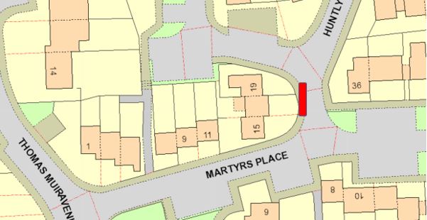
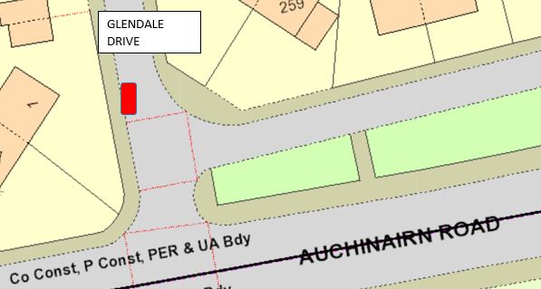
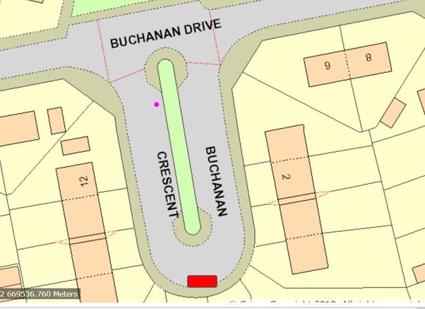
- Martyr’s Place, Glendale Drive and Buchanan Drive within Bishopbriggs;
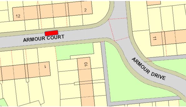
- Armour Court, Border Way, Kingsway, Hillhead Road, Kerr Street, Armour Drive, Alloway Quadrant, Drumhill, Park Street, Burns Drive, Glenconner Way, Alloway Grove and the Loaning within Kirkintilloch;
- Bencloich Crescent, Glorat Avenue, Lennox Avenue and Janefield Place within Lennoxtown;
- Oak Drive within Lenzie;
- Learnmont Place, Graham Drive, Craigash Road, Cloberfield Gardens and Park Avenue within Milngavie;
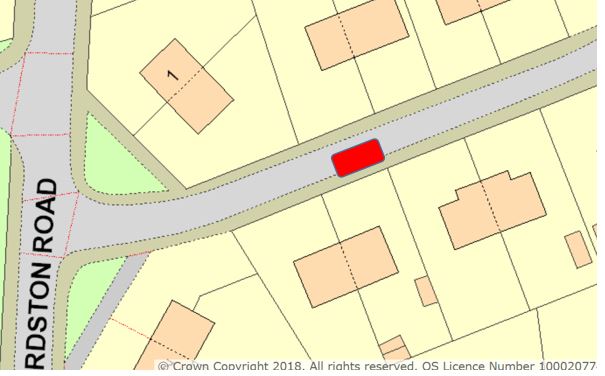
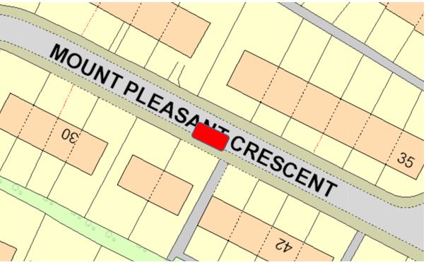
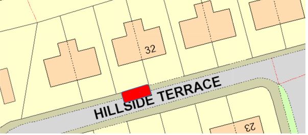
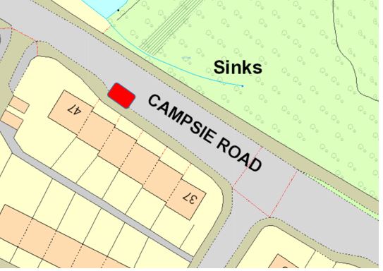
- Beechtree Terrace, Mount Pleasant Crescent, Hillside Terrace and Campsie Road Milton of Campsie;
- Mill Crescent and Campsie Road within Torrance;
- Alexander Avenue, Davidson Crescent, Differ Avenue, Gartshore Crescent, Park Avenue and Macdonald Crescent within Twechar.
- Taig Road within Waterside.
Full details of this proposal which forms the “EAST DUNBARTONSHIRE COUNCIL (DESIGNATED DISABLED PERSONS’ PARKING PLACES AND AMENDMENTS) ORDER”, are available for inspection without payment of fee in the Roads section of the East Dunbartonshire Council website. Telephone Enquiries to: 0300-123-4510.
Any person wishing to object to the proposal should send details of the grounds for objection in writing to the Chief Solicitor & Monitoring Officer, 12 Strathkelvin Place, Kirkintilloch, G66 1TJ or by email to legalservices@eastdunbarton.gov.uk by Monday, 29 May 2023.
Karen Donnelly
Chief Solicitor & Monitoring Officer
12 Strathkelvin Place
Kirkintilloch
G66 1TJ
Further information on this page:
THE EAST DUNBARTONSHIRE COUNCIL
(DESIGNATED DISABLED PERSONS’ PARKING PLACES AND AMENDMENTS) ORDER 202X
The East Dunbartonshire Council, in exercise of the powers conferred on them by Sections 32(1) and 35(1) of the Road Traffic Regulation Act 1984 (“the Act”) and of all other enabling powers and after consultation with the Chief Constable of the Police Service of Scotland in accordance with Part III of Schedule 9 to the Act hereby make the following Order.
- This Order may be cited as “The East Dunbartonshire Council (Designated Disabled Persons’ Parking Places and Amendments) Order 20XX” and shall come into operation on XXX 20XX;
- In this Order the following expressions have the meanings hereby assigned to them:-
“vehicle” unless the context otherwise requires, means a vehicle of any description and includes a machine or implement of any kind drawn or propelled along roads whether or not by mechanical power;
“disabled person’s badge” has the same meaning as in the Local Authorities’ Traffic Orders (Exemptions for Disabled Persons) (Scotland) Regulations 2002 as amended.
“parking place” means an area on a road which is provided for the leaving of a vehicle and is indicated in such a manner as prescribed in the Traffic Signs Regulations and General Directions 2002 as amended;
“Local Authority” means the public body, incorporated under Section 2 of the Local Government etc (Scotland) Act 1994;
“the Council” means the East Dunbartonshire Council, incorporated under the Local Government etc (Scotland) Act 1994;
- Each area of road which is described in Schedules 1, 2, 3, 4, 5, 6, 7, 8, 9 and 10 to this Order is hereby designated as a parking place.
- The parking places designated in Article 3 of this Order shall only be used subject to the provision of this Order for the leaving, at all times, of a vehicle displaying a disabled person’s badge.
- The limits of each parking place designated in Article 3 of this Order shall be indicated on the carriageway in such a manner as provided in the Traffic Sign Regulations and General Directions 2016 as amended.
- Every vehicle displaying a disabled person’s badge left in a parking place designated in Article 3 of this Order shall so stand such that no parking place is occupied by more than one such vehicle and that every part of the vehicle is within the limits of a parking place provided that, where the length of a vehicle precludes compliance with this paragraph, such vehicle shall be deemed to be within the limits of a parking place if:-
- the extreme front portion, or, as the case may be, the extreme rear portion of the vehicle is within 300mm of an indication on the carriageway provided under Article 5 of this Order in relation to the parking place; and
- the vehicle, or any part thereof, is not within the limits of any adjoining parking place.
- Any person duly authorised by the Council or a police constable in uniform or a traffic warden in uniform may move or cause to be moved in case of an emergency, to any place they think fit, vehicles left in a parking place.
- (i) Any person duly authorised by the Council may suspend the use of a parking place or any part thereof whenever such suspension is considered reasonably necessary:-
- for the purpose of facilitating the movement of traffic or promoting its safety; or
- for the purpose of any building operation, demolition or excavation in or adjacent to the parking place or the maintenance, improvement or reconstruction of the parking place or the laying, erection, alteration, removal or repair in or adjacent to the parking place of any sewer or of any main, pipe or apparatus for the supply of gas, water or electricity or of any telecommunications apparatus, traffic sign or parking meter; or
- for the convenience of occupiers of premises adjacent to the parking places on any occasion of the removal of furniture from one office or dwelling house to another or the removal of furniture from such premises to a depository or to such premises from a depository; or
- on any occasion on which it is likely by reason of some special attraction that any street will be thronged or obstructed; or
- for the convenience of occupiers of premises adjacent to the parking place at times of weddings or funerals, or on other special occasions;
- Any person duly authorised by the Council or a police constable in uniform or a traffic warden in uniform may suspend the use of a parking place or any part thereof whenever such suspensions is considered reasonably necessary for the purpose of facilitating the movement of traffic or promoting its safety.
- The Order specified in Schedule 11 to this order shall have effect subject to the amendments specified in that Schedule 11.
IN WITNESS WHEREOF these presents consisting of three pages and the following twenty one pages of Schedules only are executed as follows:-
|
Subscribed for and on behalf of THE EAST DUNBARTONSHIRE COUNCIL By
___________________________ Karen Donnelly Chief Solicitor and Monitoring Officer
__________________ Place of Signing
____ Date of signing
|
______________________________ Witness Signature
______________________________ Witness Name
______________________________ Address
______________________________ |
|---|
SCHEDULE 1
DESIGNATED PARKING PLACES FOR THE LEAVING OF A VEHICLE DISPLAYING A DISABLED PERSON’S BADGE
|
Area of Roads Designated as Parking Places for the leaving of a vehicle displaying a Disabled Person’s Badge, within Bearsden |
|---|
|
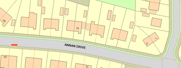
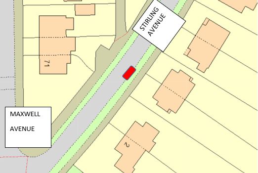
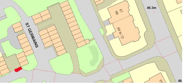
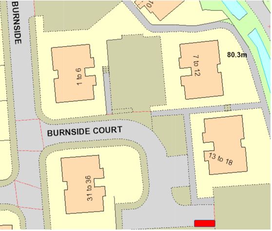
North bound of Annan Drive, which meets Tweed Drive, from the extended kerb line 120metres which is bounded on the west side kerbline of Tweed Drive, has a length of 2 metres, and along the westline kerbline for 6.6 metres. North bound of Stirling Avenue, which meets Maxwell Avenue, from the extended kerb line 41 metres, which is bounded on the east side kerbline of Maxwell Avenue, has a length of 3 metres, along the eastside kerbline for 6.6 metres. North West bound of Drymen Road, which meets St Germains, from the extended kerb line 75 metres, which is bounded on the west side kerbline, has a length of 2.5 metres, along the westside kerbing for 5 metres. South East of Burnside road, towards Burnside Court from the junction kerb line 80 metres, which is bounded south east of the kerb line, has a length of 2.5 metres, with 6.6 metres. |
Karen M. Donnelly
Chief Solicitor and Monitoring Officer
SCHEDULE 2
|
Area of Roads Designated as Parking Places for the leaving of a vehicle displaying a Disabled Person’s Badge, within Bishopbriggs |
|---|
|
North bound on Martyr’s place, from extended kerbline of Thomas Muir Avenue, of 60 metres. Moving South West of the kerbline towards Martyr’s place (Opposite Huntly Court) bounded on the westside kerb line, has a length of 2 metres, with 6.6 metres. North east bound of Glendale Drive, which meets Auchinairn Road, from the extended kerb line 15 metres which is bounded on the north side kerbline of Auchinairn Road (opposite Auchinairn main road), has a length of 2 metres, and along north line kerbline for 6.6 metres. West Bound on Buchanan Drive, which meets Woodhill Road, from the extended kerb line 50 metres, which is bounded on the south side kerbline of Buchanan Crescent 50 metres into cul-de-sac on the south kerbline of U-Bend. |
Karen M. Donnelly
Chief Solicitor and Monitoring Officer
SCHEDULE 3
|
Area of Roads Designated as Parking Places for the leaving of a vehicle displaying a Disabled Person’s Badge, within Kirkintiloch |
|---|
|
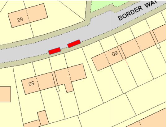
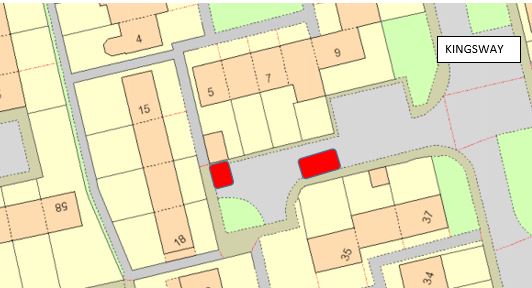
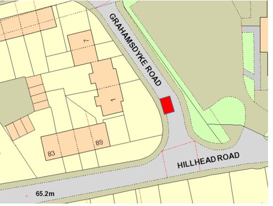
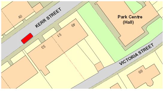
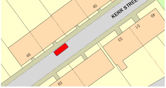
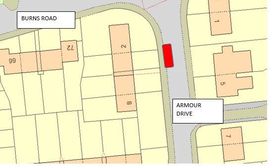
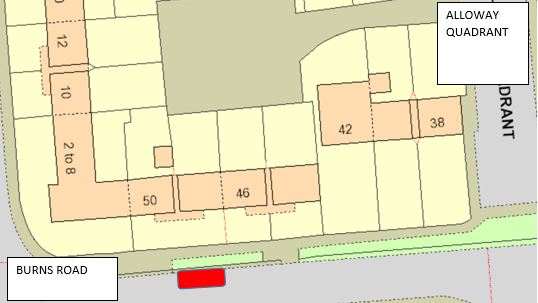
South side of Armour Court, which is bounded on the south by the kerbline of Armour Court, has a width throughout of 2 metres and extends from a point 35 metres west of the extended west kerbline of Armour Drive westwards for a distance of 6.6 metres. Southeast side of Border Way, which is bounded on the southeast by the kerbline of Border Way, has a width throughout of 2 metres and extends from a point 38 metres northeast of the extended east kerbline of Eildon Road north-eastwards for a distance of 6.6 metres. (Adjacent to no.54) Southeast side of Border Way, which is bounded on the southeast by the kerbline of Border Way, has a width throughout of 2 metres and extends from a point 45 metres northeast of the extended east kerbline of Eildon Road north-eastwards for a distance of 6.6 metres. (Adjacent to no.56) North side of Kingsway (adjacent to the boundary of no. 16 Kingsway), which is bounded on the north by the kerbline of Kingsway, has a length throughout of 5 metres and extends from a point 20 metres west of the extended west kerbline of Kingsway (adjacent to the east boundary of nos. 10-14 Kingsway), westwards for a distance of 3.6 metres. North side of Kingsway (adjacent to the boundary of no. 35 Kingsway), which is bounded on the north by the kerbline of Kingsway, has a length throughout of 5 metres and extends from a point 45 metres west of the extended west kerbline of Kingsway, westwards for a distance of 3.6 metres. North side of Hillhead Road (adjacent to no.89 Hillhead) the bay is located north east of Hillhead (no.89) on Grahamsdyke Road, on the north east kerbline, has a width of around 2 metres and extends from a point of 12 metres heading north Hillhead Road, distance of around 6.6 metres. South side of Hillhead Road (adjacent between no.74 and no.82 Hillhead road) bounded on the south east kerbline of Hillhead road, has a width of around 2 metres and extends from a point of 42 metres heading west of Cleddens Road, distance of around 6.6 metres. South east side of Kerr Street (adjacent to no.53) bounded on the south side kerbline of Kerr Street, has a width of around 2 metres and extends from a point of 105 west of Oxford Street, distance of around 6.6 metres. North west side of Kerr Street (adjacent to no.44) bounded on the north west kerbline of Kerr Street, has a width of around 2 metres and extends from a point of 145 west of Oxford Street, distance of around 6.6 metres. North side of Armour Drive (adjacent to no.4) bounded on the west side kerbline of Armour Drive, has a width of around 2 metres and extends from a point of 17 metres from the extended kerbline of Burns Road heading south east, distance of around 6.6 metres. South side of Alloway Quadrant, bounded on the southwest kerbline of Alloway Quadrant, has a width of around 2.5 metres and extends from a point of 27 metres from the extended kerbline of Burns road heading south west, distance of around 6.6 metres. |
|
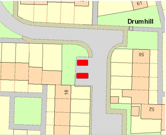
South east on Drumhill, bounded on the south kerbline, has a width of around 2.5 metres and extends from a point of 55 metres from the start of Drumhill (adjacent to house no13 and 24) heading south towards the turning head area of Drumhill, distance of around 6.6 metres. |
|
South east on Drumhill, bounded on the south kerbline, has a width of around 2.5 metres and extends from a point of 55 metres from the start of Drumhill (adjacent to house no13 and 24) heading south towards the turning head area of Drumhill, distance of around 6.6 metres. |
|
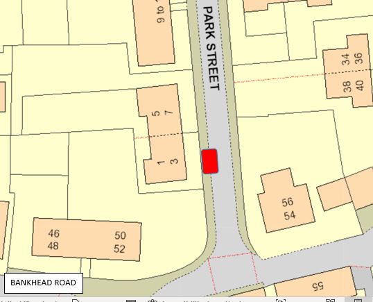
West side of Park Street (adjacent to no1 Park Street) bounded on the west side kerbline , has a width of around 2.5 metres and extends from a point of 35 metres heading north east from Alexander Place, distance of 6.6 metres. |
|
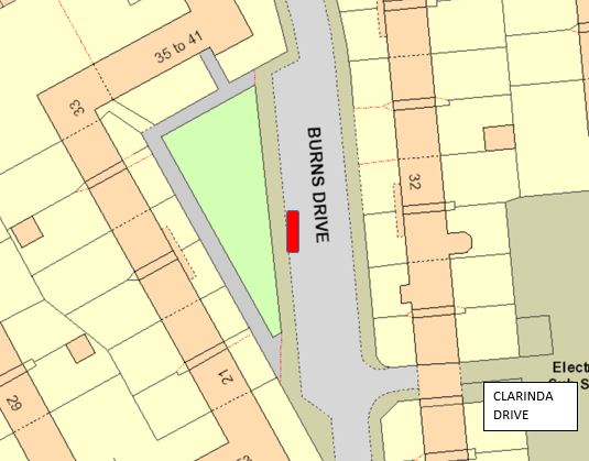
North west of Burns Drive, bounded on the west kerbline, has a width of around 2.5 metres, extends from a point of 24 metres south west from Clarinda Drive, distance of 6.6 metres . |
|
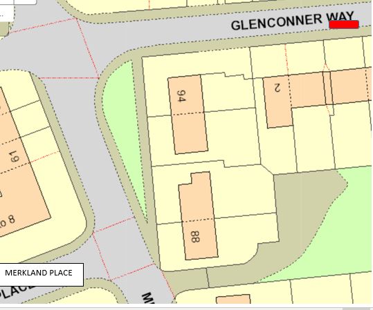
South side of Glenconner Way, bounded on the south kerbline, has a width of around 2 metres, extends form a point of 50 metres of the extending kerbline, heading east of Merkland Drive , distance of around 6.6 metres. |
|
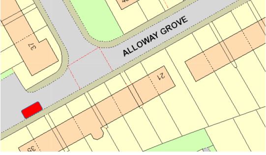
North west side of Alloway Grove (adjacent to no.25) bounded on the west kerbline, has a width of around 2.5 metres, extends from a point of 97 metres from the start of Alloway Grove , heading west and a distance of 6.6 metres. |
|
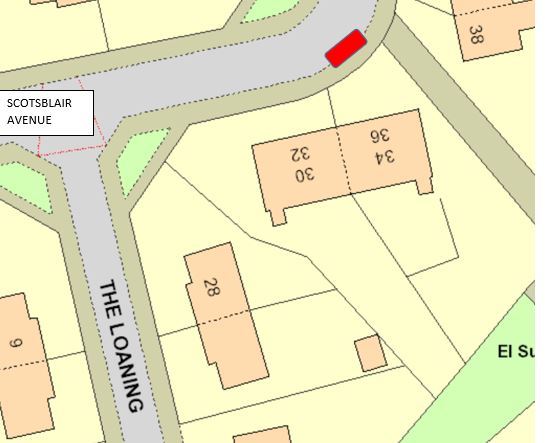
South east of the Loaning, (adjacent to no36. Shown on google maps as the opposite side of the road , no.36 is next to no30. Bounded on the south east kerbline, width of 2 metres, distance of 6.6 metres, 75 metres heading south east from Greens Crescent. |
Karen M. Donnelly
Chief Solicitor and Monitoring Officer
SCHEDULE 4
|
Area of Roads Designated as Parking Places for the leaving of a vehicle displaying a Disabled Person’s Badge, within Lenzie |
|---|
|
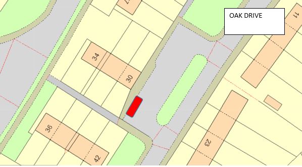
Northwest of Oak Drive (adjacent to the boundary of no34 Oak Drive) which is bounded onto the northwest kerbline of Oak Drive, has a width throughout of 2 metres and extends from a point of 48 metres north of the extended kerbline of Almond drive for a distance of 6.6 metres. |
Karen M. Donnelly
Chief Solicitor and Monitoring Officer
SCHEDULE 5
|
Area of Roads Designated as Parking Places for the leaving of a vehicle displaying a Disabled Person’s Badge, within Lennoxtown |
|---|
|
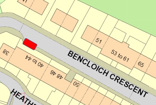
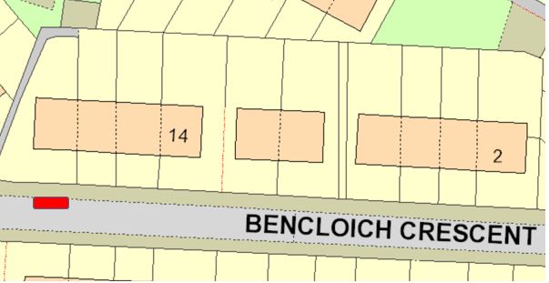
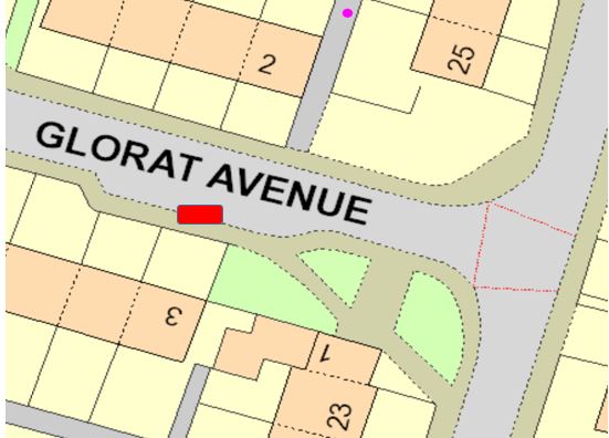
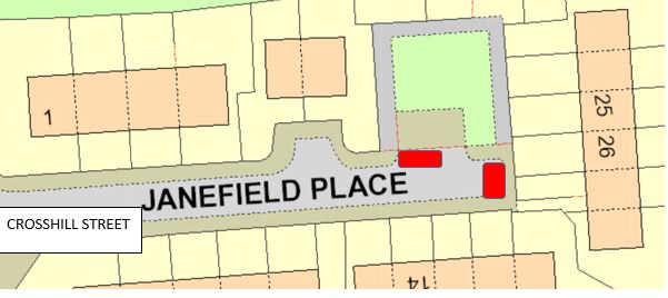
Southwest side of Bencloich Crescent (adjacent to the boundary of no. 44 Bencloich Crescent), has a width throughout of 2 metres and extends from a point of 120 metres west of the extended kerbline of Bencloich Road north-westwards for a distance of 6.6 metres. Eastside of Bencloich Crescent (adjacent to the boundary of no. 20 Bencloich Crescent), has a width throughout of 2 metres and extends from a point 100 metres northwest of the extended northwest kerbline of Bencloich Road for a distance of 6.6 metres. Southeast side of Glorat Avenue, (adjacent to the boundary of no3 Glorat Avenue) which is bounded on the southeast kerbline of Glorat Avenue, has a width throughout of 2 metres and extends from a point 19 metres northwest of the extended west kerbline of Holyknowe Road north-westwards for a distance of 6.6 metres. Eastside of Janefield Place (adjacent to the boundary of no22 Janefield Avenue) which is bounded onto the southeast kerbline of Janefield Avenue, has a width throughout of 2 metres and extends from a point of 65 metres east of the extended kerbline of Crosshill Street for a distance of 6.6 metres. Northside of Janefield Place (Opposite to the boundary of no21 Janefield Avenue) which is bounded onto the northeast kerbline of Janefield Avenue, has a width throughout of 2 metres and extends from a point of 65 metres east of the extended kerbline of Crosshill Street for a distance of 6.6 metres. |
Karen M. Donnelly
Chief Solicitor and Monitoring Officer
SCHEDULE 6
|
Area of Roads Designated as Parking Places for the leaving of a vehicle displaying a Disabled Person’s Badge, within Milngavie |
|---|
|
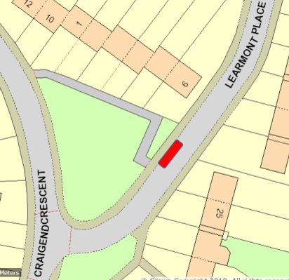
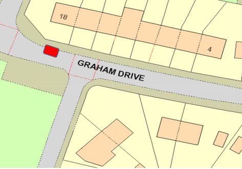
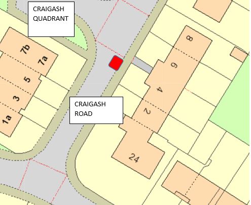
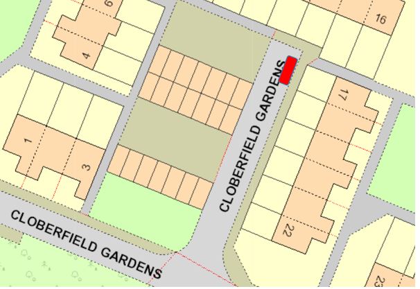
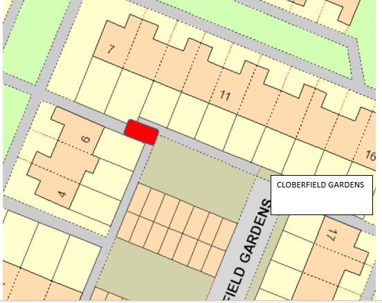
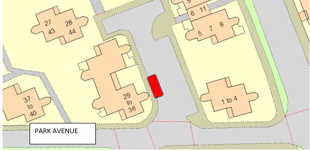
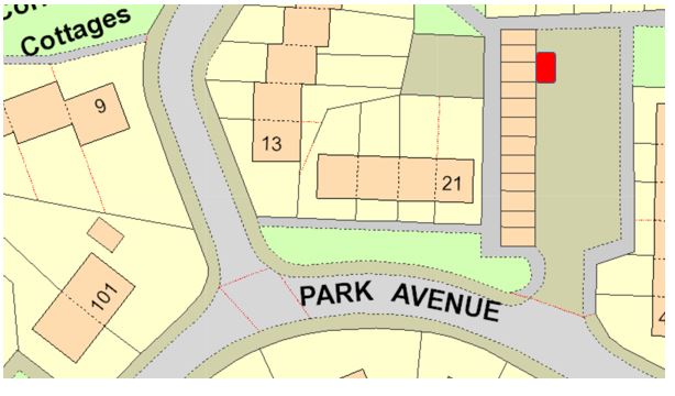
Northeast of Learnmont Place (opposite no4 Learnmont Place) which is bounded onto the northeast kerbline of Learnmont Place, has a width throughout of 2 metres and extends from a point of 30 metres east of the extended kerbline of Craigend Crescent for a distance of 6.6 metres. Southwest side of Graham Drive, which is bounded on the southwest by the kerbline of Graham Drive, has a width throughout of 2 metres and extends from a point 19 metres west of the extended kerbline of Craigend Crescent for a distance of 6.6 metres. Northeast side of Craigash Road, which is adjacent to no4 Craigash Road, bounded onto the north kerbline of craigash road, has a width throughout of 2 metres and extends from a point of 27 metres north of the extended kerbline of Hilton Road for a distance of 6.6 metres. East side of Cloberfield Gardens, which is adjacent to no17 Cloberfield Gardens, bounded onto the northeast kerbline of Cloberfield Gardens, has a width throughout of 2 metres and extends from a point of 52 metres heading west into Cloberfield Gardens , and has a distance of 6.6 metres. Southwest side of Cloberfield Gardens, which is adjacent to no8 Cloberfield Gardens, bounded onto the northwest kerbline of Cloberfield Gardens, has a width throughout of 2 metres and extends from a point of 52 metres heading west into Cloberfield Gardens, and has a distance of 6.6 metres. North side of Park Avenue, which is adjacent to no29 Park Avenue, bounded onto the northeast kerbline of Park Avenue, has a width throughout of 2 metres and extends from a point of 41 metres heading west from Park Road, north of 41metres west, this bay has a width throughout of 2 metres and distance of 6.6 metres. |
Karen M. Donnelly
Chief Solicitor and Monitoring Officer
SCHEDULE 7
|
Area of Roads Designated as Parking Places for the leaving of a vehicle displaying a Disabled Person’s Badge, within Milton of Campsie |
|---|
|
South side of Beechtree Terrace, bounded onto the south side kerbline, has a width of around 2 metres and extends from a point of 50 metres heading east from Birdston Road, with a distance of around 6.6 metres. South side of Mount Pleasant Crescent, (adjacent to no. 36) bounded to the south side kerbline, has a width of around 2 metres and extends from a point of 65 metres heading south west from Campsie Road, with a distance of around 6.6 metres. North side of Hillside Terrace (adjacent to number 30) bounded to the north side kerbline, has a width of around 2 metres and extends from a point of 65 metres south west of Cairnview road into Hillside Terrace, with a distance of around 6.6 metres. North side of Campsie Road (adjacent to number 45) bounded to the north side kerbline, has a width of around 2 metres and extends from a point of 40 metres heading south west from Mount Pleasant Crescent, with a distance of around 6.6 metres. |
Karen M. Donnelly
Chief Solicitor and Monitoring Officer
SCHEDULE 8
|
Area of Roads Designated as Parking Places for the leaving of a vehicle displaying a Disabled Person’s Badge, within Torrance |
|---|
|
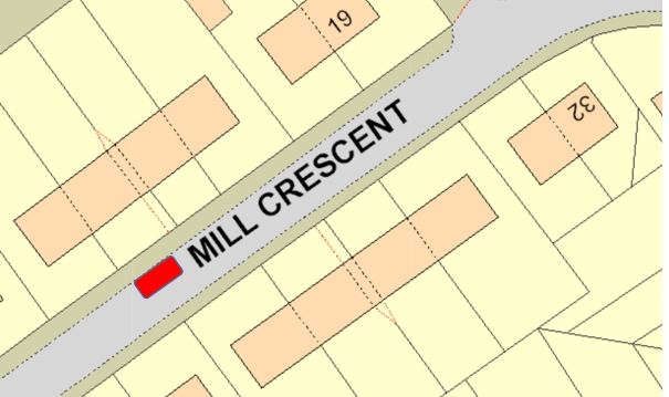
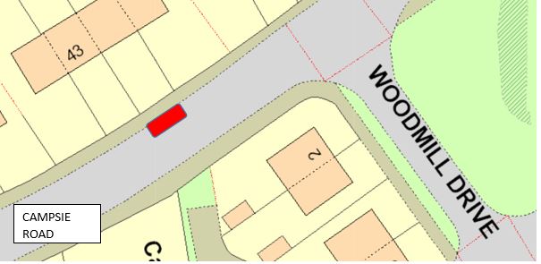
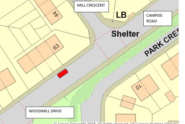
Northwest side of Mill Crescent, which is bounded by the kerbline of the cul-de-sac off Mill Crescent, adjacent school road, has a width throughout of 2.7 metres and extends from a point 60 metres west of the extended east kerbline of the access road leading to the cul-de-sac area for 6.6 metres. Northwest side of Campsie Road (adjacent no45 Campsie Road) bounded to the west side kerbline of Campsie Road, has a width throughout of 2 metres and extends from a point of 24 metres west of Woodmill Drive, with a distance of 6.6 metres. Northeast side of Campsie Road (adjacent no61 Campsie Road) bounded to the east side kerbline of Campsie Road, has a width throughout of 2 metres and extends from a point of 36 metres east of Woodmill drive, with a distance of 6.6 metres. |
Karen M. Donnelly
Chief Solicitor and Monitoring Officer
SCHEDULE 9
|
Area of Roads Designated as Parking Places for the leaving of a vehicle displaying a Disabled Person’s Badge, within Twechar |
|---|
|
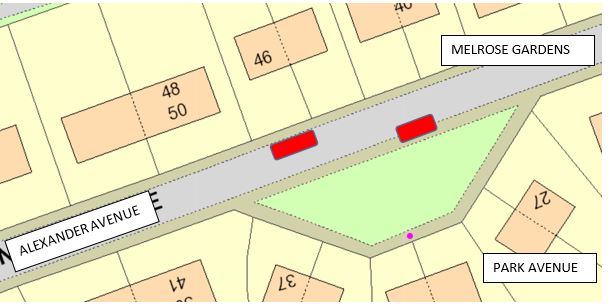
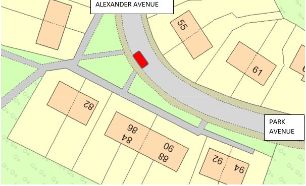
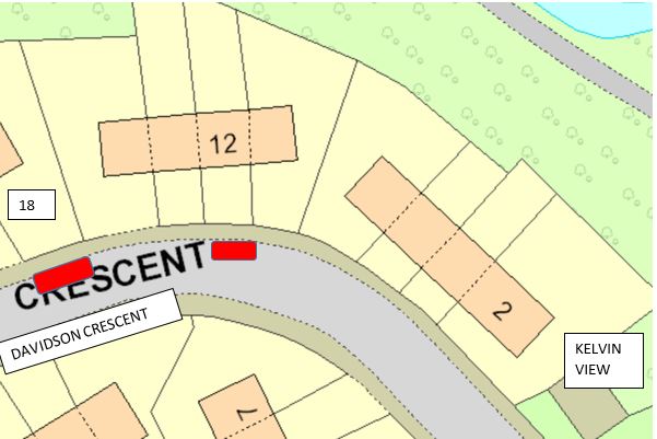
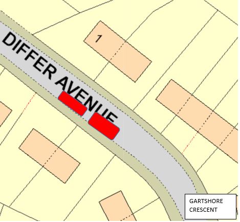
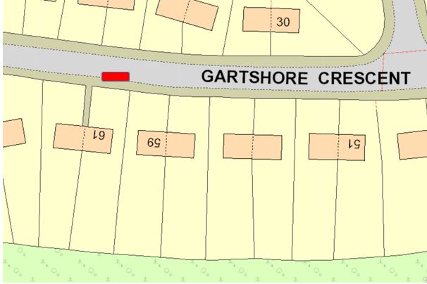
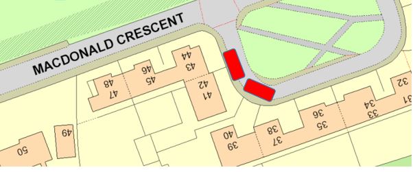
Northeast side of Alexander Avenue (adjacent number 46 Alexander Avenue) bounded to the west side kerbline of Alexander Avenue, has a width throughout of 2 metres and extends from a point of 130 from the extended kerbline of Park Avenue heading west, with a distance of 6.6 metres. South side of Alexander Avenue (adjacent number 31 Alexander Avenue) bounded to the northeast side kerbline of Alexander Avenue, has a width throughout of 2 metres and extends from a point of 97 from the extended kerbline of Park Avenue heading west, with a distance of 6.6 metres. Southwest side of Alexander Avenue (adjacent number 82 Alexander Avenue) bounded to the south west side kerbline of Alexander Avenue, has a width throughout of 2 metres and extends from a point of 200 from the extended kerbline of Park Avenue heading west towards the end of the bend of Alexander Avenue , with a distance of 6.6 metres. South west side of Davidson Crescent (adjacent number 12 Davidson Crescent) bounded to the north side kerbline of Davidson Crescent, has a width throughout of 2 metres and extends from a point of 63 metres north of Kelvin View, with a distance of 6.6 metres. South west side of Davidson Crescent (adjacent number 18 Davidson Crescent) bounded to the north side kerbline of Davidson Crescent, has a width throughout of 2 metres and extends from a point of 85 metres north of Kelvin View, with a distance of 6.6 metres. Northwest side of Differ Avenue (Adjacent number 12 Differ Avenue) bounded on the north side kerbline of Differ Avenue, has a width throughout of 2 metres and extends from a point of 53 metres north of Gartshore Crescent, with a distance of 6.6 metres. Northwest side of Differ Avenue (Adjacent number 14 Differ Avenue) bounded on the north side kerbline of Differ Avenue, has a width throughout of 2 metres and extends from a point of 60 metres north of Gartshore Crescent, with a distance of 6.6 metres. Southwest side of Gartshore Crescent (adjacent number 61 Gartshore Crescent) bounded to the south side kerbline of Gartshore Crescent, has a width throughout of 2 metres and extends from a point of 70 metres west of Differ Avenue, with a distance of 6 metres. |
|
North side of Park Avenue, bounded onto the northwest kerbline of Park Avenue parking area, has a width of 2 metres and extends from a point of 45 metres north east of Alexander Avenue, with distance of 6 metres. |
|
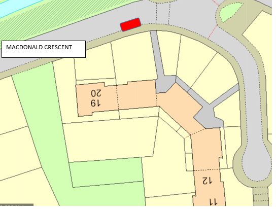
Southwest side of Macdonald Crescent (adjacent number 39 Macdonald Crescent) bounded onto the west kerbline, has a width of 2 metres and extends from a point of 65 metres (from Twechar Post Office) into cal-de-sac on MacDonald crescent heading south east, with a distance of 6.6 metres. |
|
Southwest side of Macdonald Crescent (adjacent number 18 Macdonald Crescent) bounded onto the west kerbline, has a width of 2 metres and extends from a point of 35 metres heading west from Main Street, with a distance of 6.6 metres. |
|
Southwest side of Macdonald Crescent (adjacent number 41 Macdonald Crescent) bounded onto the west kerbline, has a width of 2 metres and extends from a point of 60 metres (from Twechar Post Office) into cal-de-sac on MacDonald crescent heading east, with a distance of 6.6 metres. |
Karen M. Donnelly
Chief Solicitor and Monitoring Officer
SCHEDULE 10
|
Area of Roads Designated as Parking Places for the leaving of a vehicle displaying a Disabled Person’s Badge, within Waterside |
|
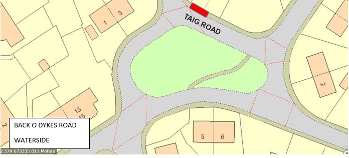
North west on Taig Road (adjacent to no.43 Taig Road) bounded on the north east kerb line, has a width of 2 metres, extends from a point of 48 metres south east of the extended kerbline of Taig Gardens, distance of 6.6 metres. |
Karen M. Donnelly
Chief Solicitor and Monitoring Officer
SCHEDULE 11
|
Name of Order |
Extent of Amendment |
|---|---|
|
The East Dunbartonshire Council (Designated Disabled Persons’ Parking Place Consolidation) Order 2018.
|
In Extent of Amendment That part of the northwest side of Aviemore Gardens which is bounded on the northwest by the kerbline of Aviemore Gardens, has a width throughout of 2 metres and extends from a point 2.8m metres south west of the extended west kerbline of Kinnaird Crescent south-westwards for a distance of 6.6 metres. That part of the southeast side of Roman Court which is bounded on the southeast by the kerbline of Roman Court, has a width throughout of 2.4 metres and extends from a point 49.7 metres northwest of the extended north kerbline of Roman Road for a distance of 5.6 metres |
|
The East Dunbartonshire Council (Designated Disabled Persons’ Parking Place Consolidation) Order 2018. |
In Schedule 2, under the heading of “Area of Roads Designated as Parking Places for the leaving of a vehicle displaying a Disabled Persons’ Badge within Bishopbriggs”, delete all reference to the following text:- That part of the southwest side of Lennox Crescent which is bounded on the southwest by the kerbline of Lennox Crescent, has a width throughout of 2 metres and extended from a point 58.1 metres northwest of the southeast kerbline of Lennox Crescent (adjacent to the northwest boundary of the Nursery) north-westwards for a distance of 6.6 metres. |
|
The East Dunbartonshire Council (Designated Disabled Persons’ Parking Place Consolidation) Order 2018.
|
In Schedule 3, under the heading of “Area of Roads Designated as Parking Places for the leaving of a vehicle displaying a Disabled Persons’ Badge within Kirkintilloch”, delete all reference to the following text:- That part of the west side of Armour Gardens which is bounded on the west by the kerblines of Armour Gardens, has a length throughout of 5 metres and extends from a point 3.6 metres north of the south kerbline of Armour Gardens (adjacent to the north boundary of nos 1-3 Armour Gardens) northwards for a distance of 3.6 metres. That part of the south side of Carrick Court which is bounded on the south by the kerbline of Carrick Court, has a length throughout of 5 metres and extends from a point 8.2 metres west of the east boundary of Carrick Court (adjacent to the west boundary of 19 Carrick Court) westwards for a distance of 3.6 metres. That part of the south side of Kingsway which is bounded on the south by the kerbline of Kingsway, has a length throughout of 5 metres and extends from a point 38.7 metres southwest of the extended west kerbline of Kingsway (adjacent to the east boundary of 37 Kingsway) south-westwards for a distance of 2.8 metres. That part of the southwest side of Industry Street which is bounded on the southwest by the kerbline of Industry Street, has a width throughout of 2 metres and extends from a point 38.4m metres northwest of the extended west kerbline of Loch Road north-westwards for a distance of 6.6 metres. That part of the northwest side of Whitehill Avenue which is bounded on the northwest by the kerbline of Whitehill Avenue, has a width throughout of 2 metres and extends from a point 97 metres southwest of the extended southwest kerbline of Whitehill Crescent south-westwards for a distance of 6.6 metres. That part of the west side of Woodhead Avenue which is bounded on the west by the kerbline of Woodhead Avenue, has a width throughout of 2 metres and extends from a point 1.3 metres south of the extended south kerbline of Woodhead Avenue (adjacent to the north boundary of property no, 27 Woodhead Avenue) southwards for a distance of 6.6 metres. |
|
The East Dunbartonshire Council (Designated Disabled Persons’ Parking Place Consolidation) Order 2018. |
In Schedule 4, under the heading of “Area of Roads Designated as Parking Places for the leaving of a vehicle displaying a Disabled Persons’ Badge within Lenzie”, delete all reference to the following text:- That part of the southeast side of Haystack Place which is bounded on the southeast by the kerbline of Haystack Place, has a width throughout of 2 metres and extends from a point 37.3 metres southwest of the extended southwest kerbline of Orchard Field south-westwards for a distance of 6.6 metres. |
|
The East Dunbartonshire Council (Designated Disabled Persons’ Parking Place Consolidation) Order 2018. |
In Schedule 5, under the heading of “Area of Roads Designated as Parking Places for the leaving of a vehicle displaying a Disabled Persons’ Badge within Lennoxtown”, delete all reference to the following text:- That part of the west side of Bencloich Road which is bounded on the west by the kerbline of Bencloich Road, has a width throughout of 2 metres and extends from a point 22 metres northeast of the extended northeast kerbline of Millburn Street north-eastwards for a distance of 6.6 metres. That part of the west side of Crosshill Street which is bounded on the west by the kerbline of Crosshill Street, has a width throughout of 2 metres and extends from a point 23.8 metres north of the extended north kerbline of St Machan’s Way northwards for a distance of 6.6 metres. |
|
The East Dunbartonshire Council (Designated Disabled Persons’ Parking Place Consolidation) Order 2018.
|
In Schedule 6, under the heading of “Area of Roads Designated as Parking Places for the leaving of a vehicle displaying a Disabled Persons’ Badge within Milngavie”, delete all reference to the following text:- That part of the southwest side of Craigton Gardens which is bounded on the southwest by the kerbline of Craigton Gardens, has a width throughout of 2 metres and extends from a point 33.1 metres southeast of the extended south kerbline of Craigend Drive West south-eastwards for a distance of 6.6 metres. That part of the west side of Dumgoyne Avenue which is bounded on the west by the kerbline of Dumgoyne Avenue, has a width throughout of 2 metres and extends from a point 17 metres north of the extended north kerbline of Craigdhu Road (access road servicing properties nos. 60-114 Craigdhu Road) northwards for a distance of 6.6 metres. That part of the east side of Park Avenue which is bounded on the east by the kerbline of Park Road, has a length throughout of 5 metres and extends 5.5 metres south of the north kerbline of Park Avenue (adjacent to properties nos. 63-68 Park Avenue) southwards for a distance of 3.6 metres. That part of the west side of Strathblane Road which is bounded on the west by the kerbline of Strathblane Road, has a width throughout of 2 metres and extends from a point 1.7 metres south of the extended south kerbline of Kersland Drive southwards for a distance of 6.6 metres. |
|
The East Dunbartonshire Council (Designated Disabled Persons’ Parking Place Consolidation) Order 2018. |
In Schedule 7, under the heading of “Area of Roads Designated as Parking Places for the leaving of a vehicle displaying a Disabled Persons’ Badge within Milton of Campsie”, delete all reference to the following text:- That part of the southwest side of Mount Pleasant Crescent which is bounded on the southwest by the kerbline of Mount Pleasant Crescent, has a width throughout of 2 metres and extends from a point 40.9 metres northwest of the extended northwest kerbline of Mount Pleasant Crescent (adjacent to the southeast boundary of property no. 35 Mount Pleasant Crescent) north-westwards for a distance of 6.6 metres. |
|
The East Dunbartonshire Council (Designated Disabled Persons’ Parking Place Consolidation) Order 2018. |
In Schedule 9, under the heading of “Area of Roads Designated as Parking Places for the leaving of a vehicle displaying a Disabled Persons’ Badge within Twechar, delete all reference to the following text:- That part of the west side of Alexander Avenue which is bounded on the west by the kerbline of Alexander Avenue, has a width throughout of 2 metres and which extends from a point 253.9 metres southwest of the extended northwest kerbline of Park Avenue south-westwards for a distance of 6.6 metres. |
Karen M. Donnelly
Chief Solicitor and Monitoring Officer
THE EAST DUNBARTONSHIRE COUNCIL
THE EAST DUNBARTONSHORE COUNCIL (DESIGNATED DISABLED PERSONS’ PARKING PLACES AND AMENDMENTS) ORDER
Statement of Reasons for proposing to make the Above Order
It is considered necessary to make the above Order to designate existing disabled persons’ parking places for the leaving of a vehicle displaying a disabled person’s badge and to remove existing disabled parking places which are no longer required for use.
Sgd Karen Donnelly
Chief Solicitor & Monitoring Officer
12 Strathkelvin Place
Kirkintilloch
G66 1TJ
| Bearsden | |
|---|---|
 |
 |
 |
 |
| Bishopbriggs | |
|---|---|
 |
 |
 |
|
| Kirkintilloch | |
|---|---|
 |
 |
 |
 |
 |
 |
 |
 |
 |
 |
 |
 |
 |
 |
 |
|
| Lenzie | |
|---|---|
 |
|
| Lennoxtown | |
|---|---|
 |
 |
 |
 |
| Milngavie | |
|---|---|
 |
 |
 |
 |
 |
 |
| Milton of Campsie | |
|---|---|
 |
 |
 |
 |
| Torrance | |
|---|---|
 |
 |
 |
|
| Twechar | |
|---|---|
 |
 |
 |
 |
 |
 |
 |
 |
| Waterside | |
|---|---|
 |
|