Fresh funding to build better connections for communities and visitors along the length of the Antonine Wall has been welcomed in East Dunbartonshire.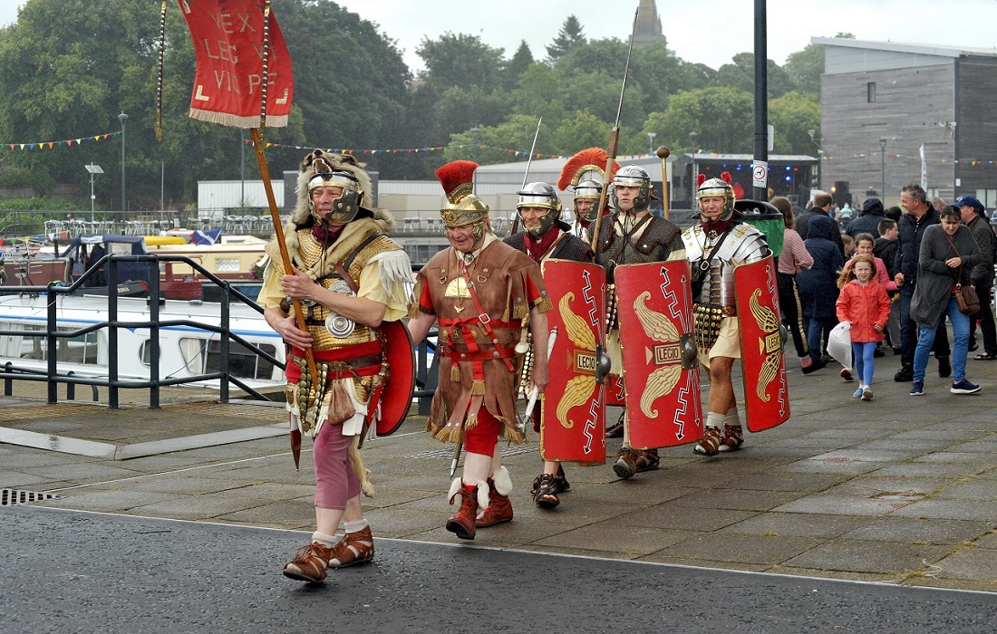
The Heritage Lottery Fund has allocated £980,600 to help raise awareness of the 63km-long World Heritage Site.
'Rediscovering the Antonine Wall' is being led by West Dunbartonshire Council, in partnership with East Dunbartonshire, Glasgow City, North Lanarkshire and Falkirk Councils, as well as Historic Environment Scotland.
The project includes plans such as:
- A Roman-themed play facility at Peel Park, Kirkintilloch
- A replica distance slab near Twechar Healthy Living & Enterprise Centre
- Community projects in Bearsden, Kirkintilloch and Twechar to connect communities better with Antonine Wall sites. These projects - informed by consultation activity - could range from exhibitions and local research projects, to arts activities and drama performances.
Resources will be developed for schools exploring topics such as Roman cooking and crafts, as well as talks, tours and a community-led video tour of the wall.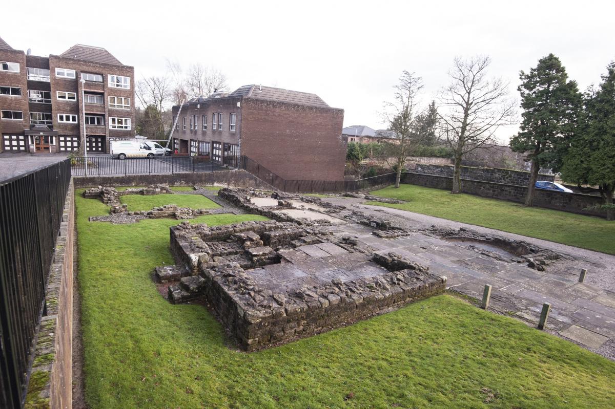
A '21st Century Legion' of 300 volunteers will be recruited and trained to help co-design projects in their communities, act as tour guides, help with research and raise awareness.
Councillor Billy Hendry, Convener of East Dunbartonshire Council’s Place, Neighbourhood & Corporate Assets Committee, said, "This is very welcome news - providing support for a unique project which will help to create a window on the rich history of the Antonine Wall, inspiring people of all ages to find out more about Scotland's past.
"East Dunbartonshire has strong links to the Roman Empire in Bearsden, Kirkintilloch, Twechar and Bishopbriggs. It's an excellent location to track down the remains of the Antonine Wall and some of the forts that lay along it.
"It's important to look at ways of exploring and maximising the heritage and history of East Dunbartonshire - raising awareness and supporting the local economy."
The HLF award provides a large proportion of the project budget, which is match funded by contributions from each of the partner local authorities and other external sources, including the LEADER programme.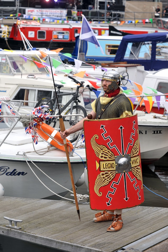
Emma McMullen, Antonine Wall HLF Project Manager, said, "We are delighted to have been awarded this funding from the Heritage Lottery Fund to support our £2.1m Rediscovering the Antonine Wall project over the next three years.
"This will give us the opportunity to work with communities along the length of the wall to better engage them with their Roman heritage, along with creating facilities that will help to promote the Antonine Wall to visitors."
The first Antonine Wall Community Conference took place recently at Glenskirlie House near Bonnybridge to mark the 10th anniversary since the inscription of the wall as an UNSECO World Heritage Site.
Visit www.antoninewall.org for more information on the wall.
Background on the Antonine Wall:
- The most awe-inspiring building project the people of Scotland had ever seen, the Antonine Wall stretched right across the country, from Clyde to Forth. Constructed around 142 AD by the Romans to mark the north-west frontier of their empire, the wall was a mighty symbol of their power and authority. Built, occupied and then abandoned by the Romans in the space of 20 years, the wall has left its mark on Scotland’s landscape.
The Antonine Wall in the East Dunbartonshire area:
- Bar Hill - the highest of all the wall forts, Bar Hill has spectacular views in all directions. The fort platform, east gate, and remains of the headquarters building (principia) and bath-house are visible today.
- Twechar - to the east of the village was a Roman temporary camp, which was probably used by legions constructing the Antonine Wall. There are no visible remains on the ground today.
- Auchendavy - a number of objects were discovered during the construction of the Forth and Clyde Canal, including altars which were dedicated by a centurion from the Second legion called Coccieus Firmus.
- Peel Park - includes the visible remains of a later medieval motte, known as the Peel, and the stone Kirkintilloch Castle, which were constructed over remains of the wall and part of the fort.
- Easter Cadder - the site of a Roman temporary camp, probably accommodating men involved in constructing the wall.
- Glasgow Bridge - midway between the forts of Kirkintilloch and Cadder - was the site of a Roman fortlet.
- Cadder - excavations have revealed that there was a Roman fort facing east and its buildings included a stone headquarters, two granaries, timber barrack blocks and two bath houses. A building inscription suggests that the Second Legion were responsible for building the fort.
- Wilderness Plantation - midway between the forts at Cadder and Balmuildy - was the site of a fortlet
- Wilderness East and West, and Buchley - sites of Roman ‘enclosures’
- Balmuildy - there was a fort on a small plateau overlooking the River Kelvin.
- Balmuildy Camp - a field to the north-east of Balmuildy fort was the site of a Roman temporary camp.
- Summerston - the east slope of Crow Hill, to the east of Bearsden, was the site of a Roman fortlet and temporary camp. It was probably the base for the construction crew of the Second Legion during the building of the wall. A distance slab of the Second Legion was found on Summerston Farm in 1694 and can now be seen in the Hunterian Museum.
- New Kilpatrick Cemetery, Bearsden - two sections of the stone base of the rampart of the Antonine Wall are visible.
- Bearsden - the best examples of stone structures along the entire Antonine Wall can be seen within a modern housing development. You can visit the exposed remains of a Roman bath-house and latrine block within the area of the fort’s annexe. A number of artefacts have been found here, including the carved head of a goddess, gaming board and a building stone inscribed by men of the Twentieth Legion.
- Roman Park, Bearsden - a well-preserved section of the ditch of the Antonine Wall and a short section of the stone base of the rampart can be found in this area.
- Castlehill - formerly the site of a fort.
Follow us on Twitter @EDCouncil or like us on Facebook for the latest updates